93L Could Become Major Hurricane in 4-5 Days; 94L Could Reach Carolinas Early Next Week
09/24/2025, 11:48 am EDT
The “Warm Blob” in the Northeast Pacific Weakens
09/28/2025, 9:36 am EDT
Climate Impact Company North Atlantic Basin 10-Day Monitor
Issued: Thursday September 25, 2025, 5:45AM EDT
Highlight: Possible hurricane (Imelda) South Carolina Coast Monday night; Humberto likely to become a major hurricane.
Discussion: Gabrielle is now a category-1 hurricane located 665 miles west of the Azores and accelerating eastward. Hurricane warnings are posted for the Azores tomorrow. Gabrielle will be a subtropical storm reaching Portugal by the weekend.
Tropical Storm Humberto is located about 480 miles east-northeast of the Leeward Islands moving northwest at 10 mph with top wind 45 mph and central pressure 1007 MB. Humberto is encountering significant wind shear likely to last into early weekend. Once the shear relaxes, Humberto’s location over warm water should allow for significant intensification. Humberto becomes a hurricane Saturday and major hurricane by late Sunday. The interaction with anticipated developing tropical cyclone Imelda makes the 3-5-day forecast track uncertain. However, a major hurricane located about 425 miles east-southeast of Cape Hatteras in 120 hours is anticipated.
Tropical Disturbance 94L is located over the eastern Dominican Republic this morning. 94L is encountering westerly shear and the high terrain of the Dominican Republic inhibiting development. However, if the inner structure of the system can bypass the upper shear and orography effects, development is likely by early weekend in the Southeast Bahamas. NOAA/NHC indicates 80% chance of a tropical cyclone after 48 hours. Tropical cyclone models indicate Imelda forms late Friday night while tracking northwestward through the eastern Bahamas with passage over warm waters enabling a hurricane by Sunday night. For now, tropical cyclone models are not indicating a major hurricane. However, ECMWF takes Imelda into the central/east-central South Carolina Coast as a hurricane late Monday.
ECMWF indicates another Mid-Atlantic system in the 11-15-day period. Both ECMEF and GFS keep the Gulf of Mexico quiet through the 15-day forecast.
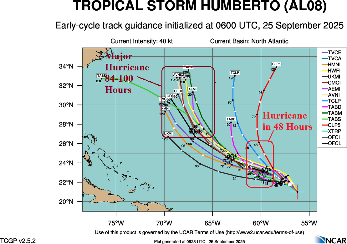
Fig. 1: Tropical Storm Humberto tropical cyclone model tracks with annotated strength based on the same models.
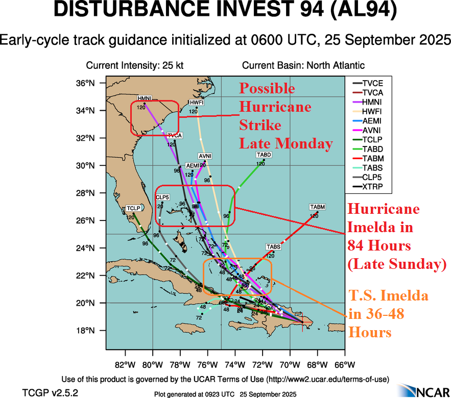
Fig. 2: Tropical Disturbance 94L tropical cyclone model tracks with annotated strength based on the same models.