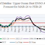
Big El Nino in 2026 Possible Followed by Returning La Nina in 2027
03/09/2026, 2:04 pm EDT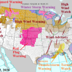
High Wind Events Northern U.S. Through Early Next Week
03/12/2026, 5:33 am EDT
Climate Impact Company Early AG Market ALERT
Issued: Wednesday March 11, 2026
Highlight: U.S. Hard Red Winter Wheat dryness, Black Sea dry concerns, wetter trend for most of South America, drier East Australia, and snowy Canadian Prairies.
Announcement from ECMWF: Coming in 2027…ERA6, the next generation of climate reanalysis from the Copernicus Climate Change Service (C3S).
C3S has started the production of our new reanalysis that responds to some of the main requests of our users. The result of almost a decade of research at the European Centre for Medium-Range Weather Forecasts – ECMWF, ERA6 will offer major improvements:
– More than double the horizontal resolution of ERA5 (down to ~14 km)
– Hourly reconstructions of the Earth system over more than 75 years
– An ocean model for consistent ocean–atmosphere–wave coupling
– Expanded historical observations, including rescued and reprocessed records
– Better access and usability for applications such as wind energy
The first decades of ERA6 will be released towards the end of 2027, with users able to download data from the first four decades by early 2028. ERA5 will continue to run operationally in parallel as long as needed.
Climate Impact Company comment: Big improvement in climate forecasts!
Discussion: A combination of zonal flow in the 1-5-day and 11-15-day period and titanic Southwest U.S. high pressure ridging in the 6-10-day period leaves the west and southwest Great Plains without rain and increasingly very warm in the latest ECM 15-day forecast (Fig. 1-2). Texas to Oklahoma shift wetter in the 16-30-day period while the western Great Plains stay dry and very warm. U.S. hard red winter wheat becomes a hot spot for drought development.
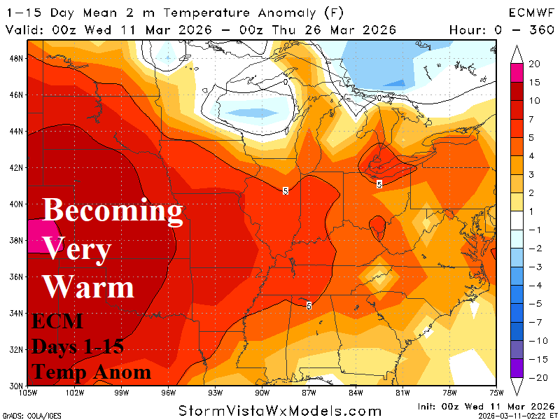
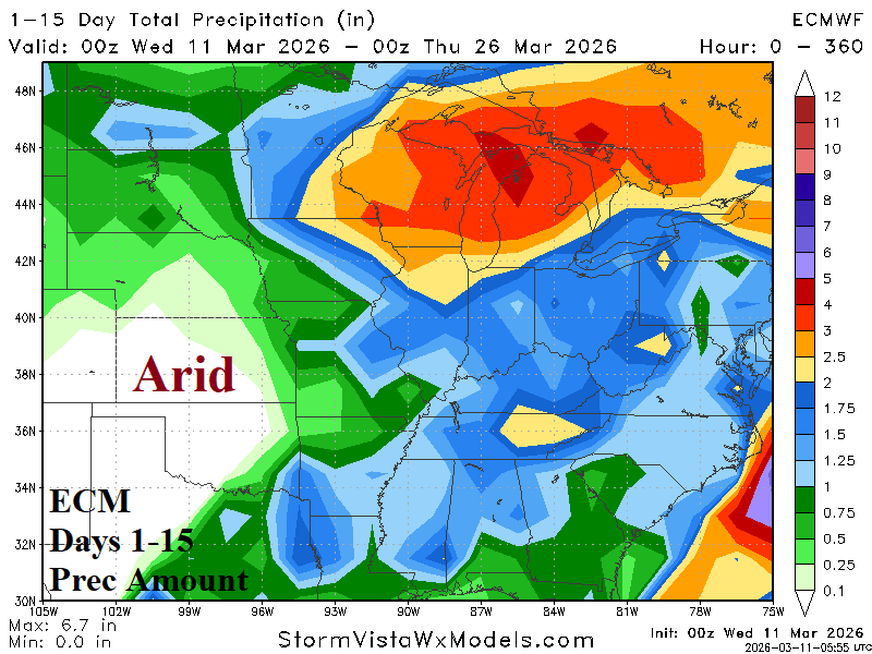
Fig. 1-2: ECM 15-day temperature anomaly and precipitation amount forecast across the U.S. AG Belt.
A second hot spot is recent dryness in the Black Sea region followed by (ECM) 15-day forecasts of developing anomalous warmth and steady dryness (Fig. 3-4). The dryness is north of a vigorous storm track extending across the Mediterranean Sea and into the Middle East over the next 2+ weeks. The Black Sea dryness is likely to last through the 16-30-day period.
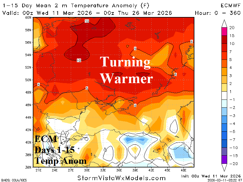

Fig. 3-4: ECM 15-day temperature anomaly and percent normal precipitation forecast across the Black Sea region.
The South America 15-day rainfall forecast features beneficial amount for much of Argentina and Brazil except for Southeast Brazil (Fig. 5). The 15-day forecast follows the recent trend of increasing rainfall arcing around Southeast Brazil (Fig. 6).
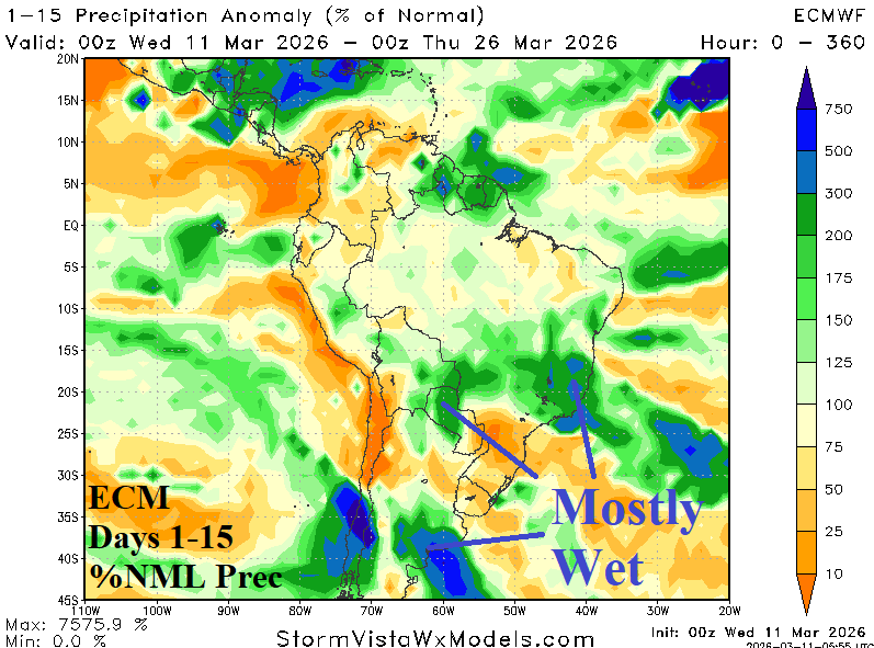
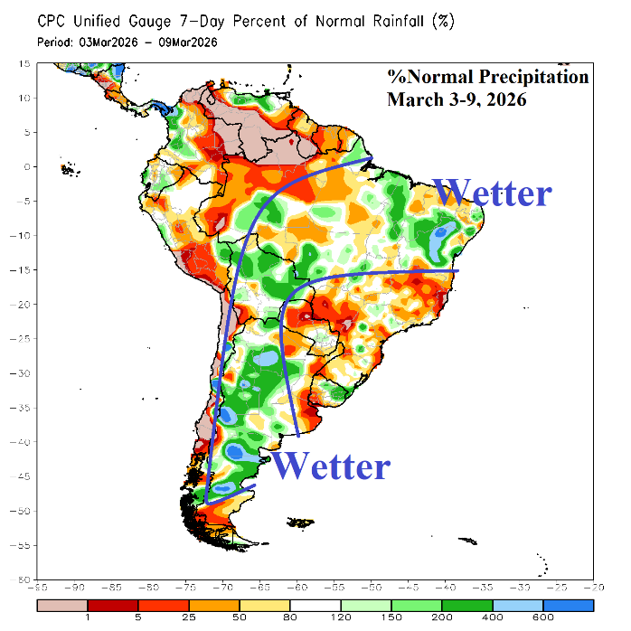
Fig. 5-6: ECM 15-day percent normal rainfall forecast across South America and the 7-day percent normal rainfall observations.
In Australia, the wet climate in the East abates and the 15-day ECM forecast indicates the Northwest Coast and West-central Australia shift much wetter (Fig. 7). An “atmospheric river” storm track into Southwest Canada extends into the Canadian Prairies delivering hefty snowfall although ECM is drier across the eastern Prairies (Fig. 8).
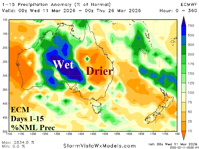

Fig. 7-8: ECM 15-day percent normal precipitation forecast across Australia and the Canadian Prairies.