Why El Nino 2023 Climate is Weaker than Historical Average
11/15/2023, 8:38 am ESTClimate Impact Company Research: Spot Check Comparing Graph Cast AI 10-Day Forecast with ECM and GFS
11/30/2023, 1:35 pm ESTDiscussion: During the past several weeks, a large area of exceptionally warm surface water has developed between 20S and 25S in the South Atlantic Ocean. Initially, the large area of warm sea surface temperature anomalies (SSTA) formed off the Southwest Africa Coast. During the past 30 days the anomalous warmth has surged westward toward the central Brazil Coast. Typical of marine heat waves (MHW), subtropical high-pressure ridging is amplified across or nearby the warm SSTA zone. During the past 30 days a strong subtropical ridge has occupied Southeast Brazil and Southwest Africa. The subtropical ridge presence is causal to a dry recent climate across much of Central and East Brazil and central and eastern portions of South Africa. The latest 15-day upper air projection across South America maintains the subtropical ridge which elongates westward from East Brazil across Bolivia and Interior South Africa and westward. More dry weather persists beneath and nearby these subtropical ridge areas increasing drought concern for Brazil and South Africa heading into December.
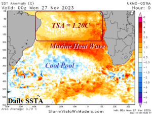
Fig. 1: A new marine heat wave has developed in the subtropical South Atlantic Ocean.
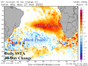
Fig. 2: The 30-day SSTA change identifies the marine heat wave as developing rapidly.
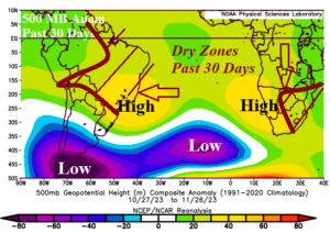
Fig. 3: Typical of marine heat waves, subtropical ridging is amplified across and nearby the warm SSTA pattern and compensated for by a strong mid-latitude upper trough.
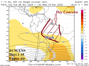
Fig. 4: The ECM ENS 15-day upper air pattern forecast across South America and the annotated dry concern zone.
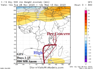
Fig. 5: The GFS 15-day upper air pattern forecast across Africa and annotated dry concern zone.
