Despite Strong El Nino Nino34 SSTA Signature, Multivariate ENSO Index Shifts Back to Neutral ENSO Phase
11/09/2023, 2:09 pm ESTNew Marine Heat Wave Causal to Brazil/South Africa Drought Risk
11/28/2023, 8:42 pm ESTExecutive summary: El Nino formed during May 2023 and oceanic El Nino has steadily intensified now considered the 7th strongest warm ENSO event since 2000. However, for the first time on record, the global climate is not responding to the El Nino warming tropical oceans. The lack of analogs prevents reliable estimates to how the DEC/JAN/FEB 2023-24 global climate will be affected. However, projections indicate greater cold and snow risk for the U.S. and Europe compared to a normal El Nino winter while typically dry Southeast Africa, Australia, and Brazil El Nino climate may be wetter than expected. Additionally, the lack of an El Nino climate may prevent oceanic El Nino from weakening as indicated by forecast models through the first half of 2024.
Discussion: According to NOAA’s operational Nino index (ONI) El Nino initiated in APR/MAY/JUN and has tripled in strength since that time. So far, oceanic El Nino is about 70% of the intensity of the 2015 warm ENSO episode and 7th strongest of all El Nino episodes since 1950. Interestingly, atmospheric El Nino as defined by multivariate ENSO index (MEI) has shifted to neutral phase during SEP/OCT after briefly reaching El Nino criteria during AUG/SEP. Oceanic El Nino is moderate intensity. The presence of moderate strength intensity of oceanic El Nino is always accompanied by an atmospheric El Nino until this year.
The rainfall pattern in the tropics across the Pacific Ocean during all El Nino’s since 2000 during AUG/SEP/OCT has produced typical heavy thunderstorm activity and attendant rainfall across the central and east-central Pacific (Fig. 1). To compensate, the far western tropical Pacific/Indonesia observes atmospheric subsidence and a dry climate. The vertical air motion difference between the sinking air over Indonesia and rising air near and east of the Dateline drives the El Nino climate.
During AUG/SEP/OCT 2023 the convection in the tropical Pacific is almost entirely confined to near the Dateline with areas just to the north quite dry due to subsidence. The western equatorial Pacific is observing unusual near to above normal convection (Fig. 2). Consequently, the dramatic sinking vs. rising air currents across the equatorial Pacific is not present and therefore a weaker El Nino climate.
Contributing to the weaker El Nino climate is the lack of disparity between the warm tropical Pacific and poleward waters that are also somewhat warmer than normal. The NMME JAN/FEB/MAR 2024 global SSTA outlook maintains warm mid-latitude SSTA (Fig. 3) and therefore the weaker El Nino climate is likely to persist despite oceanic El Nino peaking in intensity early in 2024 (Fig. 4).
The latest collection of dynamic and statistical ENSO phase forecast models by the International Research Institute (IRI) for Climate and Society indicates decelerating El Nino through the first half of 2024 with neutral ENSO likely for mid-year. The lack of a dynamic El Nino climate could slow the deceleration of El Nino next year.
Difficult is an estimate of what differences in a weaker El Nino climate vs. a moderately strong oceanic El Nino for DEC/JAN/FEB 2023-24 will produce due to no analogs for this regime. In the northern hemisphere, slower than usual mid-latitude westerly flow suggests buckling jet streams may occur more than normal. If so, attendant storms can entrain above normal low atmospheric moisture present due to the anomalous warm ocean and cause stronger storms. Stronger storms can release latent heat poleward and increase risk of blocking high pressure which -in-turn causes an increase in mid-latitude storms featuring snow and cold once well into winter. The colder scenario is suggested due to the significant difference of traditional mild El Nino climate (for both North America and Europe).
In the southern hemisphere, the weaker El Nino climate suggests that Southeast Africa, Australia, and Brazil could be less dry (or wetter) than a normal El Nino climate pattern for the summer months.
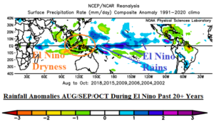
Fig. 1: Typical convection/heavy rain patterns (in blue) in the deep tropics related to El Nino episodes for AUG/SEP/OCT since 2000.
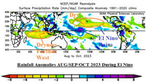
Fig. 2: Convection/heavy rain pattern (in blue) in the deep tropics related to El Nino of AUG/SEP/OCT 2023.
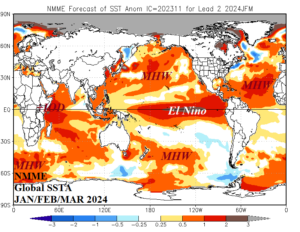
Fig. 3: The NMME global SSTA forecast for JAN/FEB/MAR 2024.
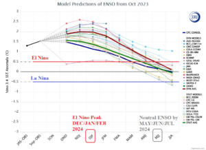
Fig. 4: A collection of all dynamic and statistical ENSO phase forecast models by the International Research Institute for Climate and Society.