Strong Negative East Atlantic/Western Russia Pattern Soaks Europe
11/06/2023, 5:52 am ESTWhy El Nino 2023 Climate is Weaker than Historical Average
11/15/2023, 8:38 am ESTExecutive summary: In October 2023, the Nino34 SSTA index was +1.59C which eclipses the +1.50C threshold for strong oceanic El Nino classification. However, the response of the atmospheric climate pattern to the El Nino warming is weak yielding neutral multivariate ENSO index (MEI = +0.3) during SEP/OCT 2023. Preliminary investigation reveals this is a first-time occurrence for a strong oceanic El Nino. A potential explanation is the relatively small zone of convective currents across the central and eastern tropical Pacific Ocean in October as identified by velocity potential anomalies (VPA) at 250 MB.
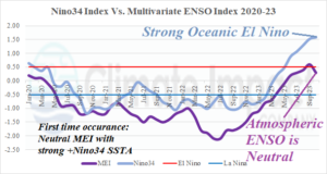
Fig. 1: Since 2020 the multivariate ENSO index was considerably stronger than the La Nina episode as defined by the Nino34 SSTA. Since the evolution of a strong El Nino in 2023, MEI has struggled to produce an El Nino climate.
Discussion: Preliminary investigation indicates for the first time (Fig. 1), a strong oceanic El Nino as defined by the Nino34 sea surface temperature anomaly (SSTA) index is accompanied by neutral phase multivariate ENSO index (MEI).
The Nino34 SSTA index identifies the ocean surface temperature compared to normal for 170W to 120W longitude between 5N and 5S latitude. The Nino34 SSTA index is the conventional climate diagnostic used to identify and forecast ENSO phase. In October 2023, the Nino34 SSTA index was +1.59C. Values greater than +1.50C are considered strong El Nino signatures.
MEI measures the atmospheric response of SSTA and sea level pressure anomalies (SLPA) across the equatorial Pacific Ocean induced by ENSO regimes. The measurement area stretches from 100E to 70W in-between 30N and 30S. The September/October 2023 MEI was +0.3 which is beneath the El Nino threshold (+0.5). MEI was briefly in an El Nino climate phase during late northern hemisphere summer but shifting to neutral phase during SEP/OCT 2023.
A possible explanation for this unique situation is identified by the October 2023 velocity potential anomaly (VPA) analysis from IRI/LDEO (Fig. 2). The analysis reveals positive values across the East Indian Ocean, Southeast Asia, and Australia which represents converging air aloft leading to subsidence in the troposphere and the sinking air motion suppresses convective clouds as identified by below normal rainfall patterns. The +VPA regime in this location during El Nino is normal although this particular signature is quite strong.
The opposite regime, diverging air aloft, is caused by convective currents associated with increased thunderstorm activity and rainfall. The -VPA regime located near and just west of the Dateline in October 2023 is unusually small given the anomalous warm SSTA inspired by El Nino near and east of the Dateline along the equator. In fact, +VPA is located over the America longitudes and extending across the far eastern MEI measurement area. Normally, most of the eastern half of the tropical Pacific would be in the blue -VPA zone during an El Nino.
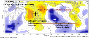
Fig. 2: As a possible explanation to a first-time neutral MEI while strong oceanic El Nino is in-place, the October 2023 velocity potential anomalies are revealed. Normally, the blue negative values would cover most of the central and eastern Pacific tropics during strong oceanic El Nino.