Amundsen Sea Low Pressure Trough Ejects Low Pressure Systems; Brings Heavy Rain to Southeast Brazil
11/03/2023, 5:45 am EDTDespite Strong El Nino Nino34 SSTA Signature, Multivariate ENSO Index Shifts Back to Neutral ENSO Phase
11/09/2023, 2:09 pm EST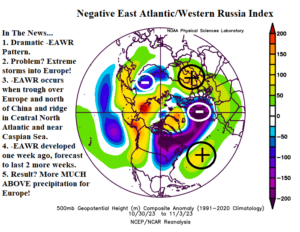
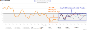
Fig. 1-2: Explaining the dynamics of negative phase East Atlantic/Western Russia index and the EAWR 15-day forecast.
Discussion: The East Atlantic/Western Russia (EAWR) index is present when a strong trough is located across Europe and north of China while amplified high pressure zones occupy the central North Atlantic and Caspian Sea region (Fig. 1). In this pattern, which developed over 1 week ago and is forecast to remain through the next 2 weeks (Fig. 2), heavy precipitation stretches across Europe as observed during the past week (Fig. 3). Included in this pattern was super storm “Cirian” slamming Western Europe mid-to-late last week with hurricane intensity. -EAWR is forecast to continue for another 2 weeks (Fig. 4), likely causing more excessive rainfall. The GFS indicates several inches of rain with high spots of 5+ inches possible in the latest 15 day forecast for much of Europe extending eastward into Western Russia and including the Black Sea region.
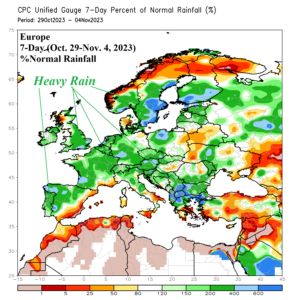
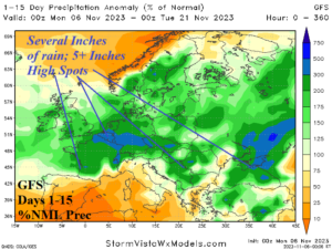
Fig. 3-4: Last week’s percent of normal precipitation across Europe and the 15-day percent of normal precipitation forecast by GFS.