New Marine Heat Wave Causal to Brazil/South Africa Drought Risk
11/28/2023, 8:42 pm ESTEl Nino to La Nina in 2024, What to Expect for DEC/JAN/FEB 2024-25
12/12/2023, 6:44 am EST10-day forecast test comparing GFS, ECM, and Graph Cast AI-generated projection results yield big win for AI.
Executive summary: A 10-day forecast of synoptic features across the U.S. valid 7PM EST on Monday November 27th was performed using a comparison between GFS, ECM, and Graph Cast AI-generated models. The results were a near perfect forecast by Graph Cast while GFS was out-of-phase with an Upper Midwest storm and attendant cold front while ECM was much too stormy across the Southern States.
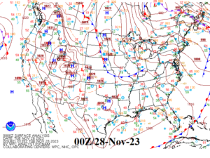
Fig. 1: NOAA/WPC synoptic weather map for 7PM EST Nov. 27, 2023.
Discussion: During the early evening (EST) on Monday November 27, a frontal boundary separating milder air across the northwest/west Great Plains and a chilly polar air mass across the Great Lakes region and into the East U.S. was present while strong high pressure was located across the eastern Great Basin and the polar front moved off the south coast of Florida (Fig. 1). The U.S. was storm free earlier this week.
What were the 10-day forecasts of this tranquil weather pattern by the GFS and ECM operational models plus the Graph Cast AI-generated 10-day outlook?
The GFS correctly projected the high-pressure area in the eastern Great Basin (Fig. 2). However, a low-pressure area over the Upper Midwest with a frontal system extending to Texas was completely out-of-phase with verification. Meanwhile, the ECM forecast was much too stormy across the Southern States plus coastal New England (Fig. 3). The model correctly projected a high pressure over the eastern Great Basin.
So, what about the AI-generated forecast?
The Graph Cast 10-day outlook correctly identified strongest high pressure for that day centered over Texas although the ridge strength into the East U.S. was too robust (Fig. 4). Graph Cast correctly pushed the southern cold front and attendant rainfall into the lower Gulf latitudes. The model also correctly projected weak low-pressure near eastern James Bay and attendant weak low-pressure trough southward into the eastern Great Lakes region. Overall, the AI-generated forecast was quite good and much better than GFS and ECM.
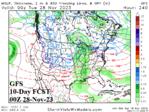
Fig. 2: The GFS 10-day forecast for 7PM EST Nov. 27, 2023.
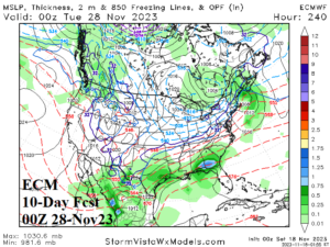
Fig. 3: The ECM 10-day forecast for 7PM EST Nov. 27, 2023.
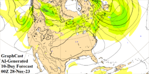
Fig. 4: The Graph Cast AI-generated 10-day forecast for 7PM EST Nov. 27, 2023.