-NAO Causes U.S. and Europe Storms Including Early Season Chill for Europe
11/13/2024, 5:49 am ESTEurope Cold and Snow Ahead!
11/15/2024, 11:31 am EST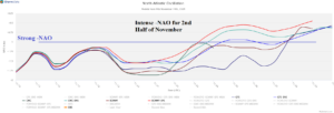
Fig. 1: Using all models, the 15-day North Atlantic oscillation index forecast indicates a strong negative phase.
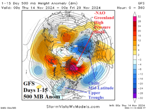
Fig. 2: The GFS 15-day northern hemisphere upper air forecast indicates a building blocking high pressure area over Greenland characteristic of -NAO.
Discussion: Likely related to latent heat release of late season tropical cyclones in both the North Atlantic and Northwest Pacific, a gathering of anomalous warm air aloft leading to a high-pressure block convenes over Greenland characteristic of a strong negative phase North Atlantic oscillation (Fig. 1-2). In the middle latitudes, compensating cold trough patterns develop and replace the prevailing very warm climate of autumn 2024. In the U.S., ECMWF projects a cold 8-14-day forecast across the Central U.S. and into the northwest Gulf of Mexico States (Fig. 3). Coldest anomalies are centered on the southwest Great Plains and Northern Texas according to ECMWF. The 32F threshold reaches the OK/TX state line and eastward early in the 11-15-day period. Enhancing the cold in the South-central U.S. is the air mass trajectory over building North-central U.S. snow cover (Fig. 4). -NAO impacts on Europe are equally impressive. The -NAO pattern produces widespread stormy weather through most of the next 10 days and gradually colder temperatures which spread across all of Europe in the 8-14-day period (Fig. 5). In the 6-10-day period, the 32F threshold reaches U.K., much of France, Northern Italy, Southeast Europe, and Turkey. The sudden sharp cold is enhanced by unusually widespread early season snow cover (Fig. 6).

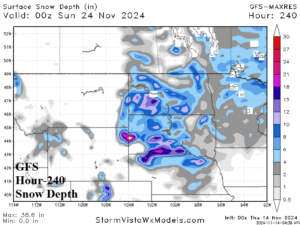
Fig. 3-4: High impact weather forecasts across the U.S. due to the -NAO regime include a chilly medium-range forecast enhanced by building snow cover.
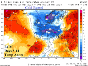
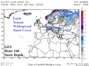
Fig. 5-6: High impact weather across Europe includes a widening cold pattern in the medium range enhanced by developing snow cover.
