Pattern Reversal: Amundsen Sea Trough Replaced by Ridge; Teleconnection to Brazil is Hot/Dry Ridge
09/18/2023, 5:12 am EDTBrazil Heatwave Locks In!
09/22/2023, 9:32 am EDT


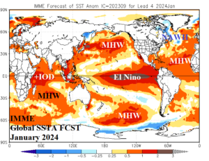
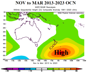
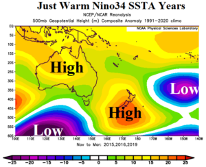
Fig. 1-3: The IMME global SSTA forecast for January 2024 and the 2013-2023 upper air pattern for Australia and vicinity compared to years within the 11-year period when Nino34 SSTA was warm.
Discussion: ENSO and IOD forecast experts, Australia Bureau of Meteorology (ABOM), stated earlier today that +IOD was underway and combined with El Nino their dry and hot forecast confidence across Australia for Q4/2023 increases. The lack of El Nino in this decade (until mid-2023) has prevented Australia from regaining hostile drought conditions. However, El Nino is back and the drying influence on Australia climate is enhanced by the +IOD pattern according to ABOM. Climate Impact Company adds one other feature to the mix. Since 2013, a “warm blob” of ocean water has occupied waters near New Zealand sometimes extending to the Southeast Australia Coast and at other times extending eastward across the subtropical South Pacific. On average, the atmosphere has responded with titanic semi-permanent high pressure centered just east of New Zealand. The warm water zone is referred to as the New Zealand marine heatwave (MHW). The influence of the MHW unique to climate during the past decade and much different from the prevailing 30-year climatology leads to inclusion of an optimum climate normal (OCN) when considering a climate explanation or projection. During the 11-year OCN when the Nino34 SSTA has featured El Nino warming, the upper ridge near New Zealand persists and also extends across Australia possibly enhancing heat and dry risk (added to ENSO and IOD influence). Proposed is an added climate diagnostic supporting an anomalous dry and hot summer 2023-24 climate pattern across Australia causing a major drought.
