Expansion of Amundsen Sea Trough Soaks South America
09/15/2023, 5:43 am EDTNew Zealand Marine Heatwave/Climate Could Add to Australia Drought Risk
09/19/2023, 7:47 am EDT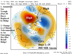
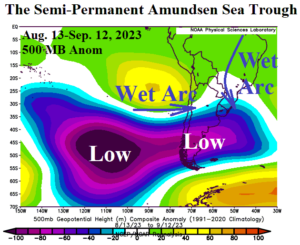
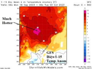
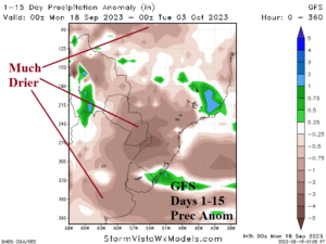
Fig. 1-4: The GFS 15-day 500 MB anomaly forecast indicates a titanic ridge replacing the Amundsen Sea low pressure trough southwest of South America causing hotter and drier weather ahead for Brazil.
South America discussion: The latest 15-day upper air forecast for the southern hemisphere (by GFS) reveals an amplifying titanic upper-level high pressure ridge developing southwest of South America (Fig. 1). Previously, the 2020-23 semi-permanent Amundsen Sea upper trough was “locked-in” the previous 30+ days (Fig. 2) and responsible in part for a wet pattern for much of Chile, Argentina, and Brazil. Not obvious is the catalyst to this change although a weak eastward extension of the Maritime Continent convection phase of the Madden Julian oscillation (MJO) is a likely contributor. Consequently, the forecast across Brazil into early October is much hotter (Fig. 3). There is widespread risk of developing >100F/38C daytime maximum temperatures in Brazil the next 2 weeks! A much drier climate also emerges. Most models feature very little rainfall in the 15-day outlook with GFS the best consensus forecast (Fig. 4). Although Climate Impact Company anticipates periods of wet weather still ahead for the next 1-2 months in East/Southeast Brazil, a major drought for Central Brazil is forecast for summer 2023-24.
Australia discussion: A major concern for summer 2023-24 in the southern hemisphere is a major drought in South America (Brazil) and Australia somewhat related to the developing El Nino climate and contributions by the positive phase Indian ocean dipole (+IOD). Early season torrid heat is developing across Australia. The 15-day outlook emphasizes unseasonably hot weather across the southern 2/3 of the continent into early October (Fig. 5). The risk of >100F/38C is spreading from primarily Western Australia in the short-term eastward to East-central Australia by the 11-15-day period (Fig. 6).
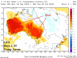
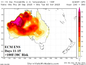
Fig. 5-6: The GFS 15-day temperature anomaly forecast across Australia and the risk of >100F/38C in the 11-15-day period projection by ECM ENS.