Mostly a Dry and Warm Week 2-4 U.S. Forecast
09/26/2024, 8:49 pm EDTNorth Atlantic Basin SSTA Status: Still Much Warmer Than Normal!
09/30/2024, 12:52 pm EDT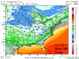
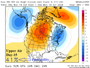
Fig. 1-2: The GFS 16-day minimum temperature forecast and 15-day upper air outlook.
Discussion: We begin at the end of the 12Z GFS model run…a cold outbreak into the U.S. as GFS takes 20’s into the Midwest and 30’s to the Tennessee Valley (Fig. 1). The mega-cluster ensemble day-15 upper air forecast supports the chill with an amplified upper trough across the Northeast U.S. (Fig. 2).
The immediate forecast issues include risk of another Gulf of Mexico tropical cyclone. NOAA/NHC identifies a tropical wave southwest of Jamaica having a 50% chance of tropical cyclone development after 48 hours. The 12Z GFS indicates the system develops slowly and eventually reaches the north/northeast Gulf of Mexico Coast early in the 6-10-day period (Fig. 3). Other models are convinced of tropical development although uncertain about development and tracking. The Gulf of Mexico tropical cyclone landfall risk for October 1-10 strongly favors the northeast Gulf/Florida versus Texas (Fig. 4). In the outer Atlantic, “fish storms” are likely to intensify.
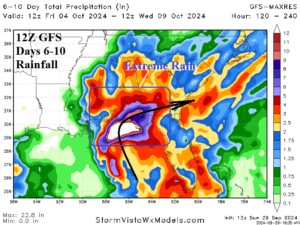
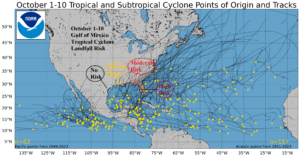
Fig. 3-4: The 12Z GFS rainfall forecast for the Southeast U.S. in the 6-10-day period and tropical cyclone risk for October 1-10.
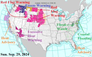
Fig. 5: NOAA/NWS weather watch, warning, and advisory areas.
The remnants of Helene shift east the next couple days to unload some moderate to heavy rain on the Mid-Atlantic region. A Flood Watch is issued for western Virginia (Fig. 5). Onshore flow keeps Coastal Flood Advisories going in the Mid-Atlantic region. Red Flag Warning’s for high fire danger extend across the northwest Great Plains and parts of the Interior Northwest. An early season chill sponsors a Freeze Warning for Northern Idaho. Meanwhile an Excessive Heat Warning is in effect for the Southwest Desert with Heat Advisories for the Central California Coast. An ongoing heatwave remains over Southeast Florida.
Largest concerns in the medium range aside from tropical cyclone risk is the excessive heat likely for the Western U.S. (Fig. 6-7). The East avoids the heat and as previously noted could be quite cool in 15 days. The U.S. gas population weight HDD forecast is steadily below normal HDD’s (Fig. 8).
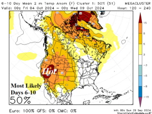
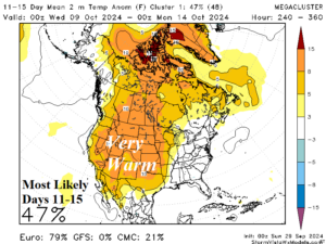
Fig. 6-7: Most likely mega-cluster ensemble U.S. temperature anomaly forecasts for the medium range.
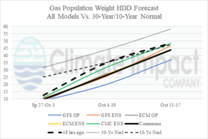
Fig. 8: The consensus of all models U.S. gas population weight HDD forecast compared with 48 hours ago and the 30-year/10-year normal.