Late Season Heatwave Focused on the Mid-Atlantic Next Week
08/31/2023, 8:25 am EDTEl Nino Continues to intensify. Doubting Super Intense El Nino. La Nina Returns in 2024
09/06/2023, 8:10 pm EDT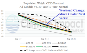
Fig. 1: U.S. population weight CDD forecast utilizing all models, their consensus, and comparison with 72 hours ago and the 10-year/30-year normal.
Discussion: Over the weekend, the forecast trend was much cooler for next week as population weight CDD forecasts plunged from about 75 CDD to near 60 CDD (Fig. 1). The forecast through the middle third of September is now closer to near normal. The mega-cluster ensemble identifies the most likely zones where anomalous warmth is present during the medium range including more heat in Texas and Mexico in the 6-10-day forecast while the Midwest is now temperate (Fig. 2) followed by a warmer Northwest projection in the 11-15-day period while Texas heat eases (Fig. 3). The cooler Central U.S. forecast is correlated to a wetter pattern.
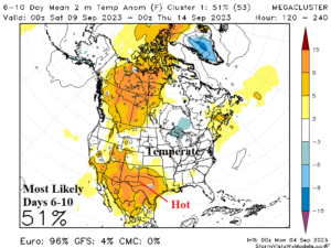
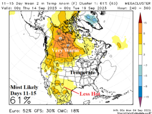
Fig. 2-3: The mega-cluster ensemble “most likely” temperature anomaly forecast for the medium range.
The tropics are generally ALL CLEAR for the moment, however, Tropical Disturbance 95L in the eastern tropical North Atlantic could become a problem in the medium range. Tropical cyclone models take 95L west-to-west-northwest over the next 5 days to a position to the northeast of the Caribbean Sea (Fig. 4). During this time NOAA indicates 90% chance of a tropical cyclone and models indicate a 1-in-4 chance of a category-4 major hurricane in 5 days (Fig. 5). In the extended-range, GFS and ECM indicate this system will approach the U.S. East Coast as a major hurricane centered on September 13-14.
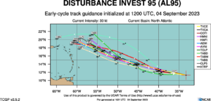
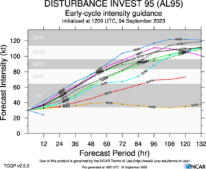
Fig. 4-5: Tropical cyclone models and their projected tracks and intensities for Tropical Disturbance 95L.
This week’s hot weather has arrived and will peak tomorrow in Des Moines to Kansas City to Cincinnati, on Wednesday in the East, and late week in Texas (Fig. 6). Expect most of these areas to gain Heat Advisories. A Red Flag Warning for high fire risk is issued for the southwest Great Plains.
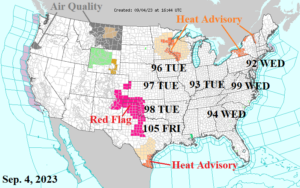
Fig. 6: NOAA/NWS weather watch, warning, and advisory areas.
