New Tropical Disturbance (95L) Could Threaten East Coast as a Major Hurricane in 10 Days
09/04/2023, 1:14 pm EDTMore High Impact Weather: Drier Midwest Forecast, Europe Heatwave, SE Brazil Floods, and New Heat Australia
09/07/2023, 8:25 am EDT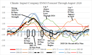
Fig. 1: Climate Impact Company ENSO forecast through August 2026 with annotated timing of events.
ENSO outlook discussion: El Nino 2023 continues to strengthen following a robust +1.30 Nino34 SSTA in August. The Nino34 SSTA has entirely reversed from a potent cool La Nina signature 1 year ago to the impressive current warm signature. Oceanic El Nino is now classified as moderate-to-strong intensity.
The Climate Impact Company constructed analog forecast is based on 7 analogs, 4 occurring during the cool (ENSO) cycle (2023 is similar) and 3 occurring during the warm cycle (Fig. 1). The analogs are in reasonable agreement on the observed Nino34 of the past 12 months, the onset and strengthening of El Nino in 2023, the peak of El Nino 2023-24 occurring in December, and weakening to a La Nina in October 2024. ENSO phase is in-and-out of La Nina for 2025-26. The “caveat” forecast is a 1-in-7 chance of El Nino continuing next year and 2026.
The analog forecast implies El Nino 2023-24 is not as strong as the 3 most intense on record (1982-83, 1997-98, and 2015-16). Reasons for the lack of super intensity despite the extremely warm Nino SSTA regions is suggested by the Northeast Pacific SSTA regime and trend in upper ocean heat.
The super El Nino of 2015-16 was created due to merging of a Northeast Pacific marine heat wave (MHW) and warm waters in the southeast Pacific tropics associated with El Nino. Once each warm zone merged, an intense El Nino formed. In 2023 a MHW north and northeast of Hawaii expands to the West Coast of North America earlier this summer season. However, the warmth reaching the coast while still present (Fig. 2) has cooled significantly during the past 30 days (Fig. 3). However, waters just off the California Coast are warmer than normal and continue to warm in recent weeks. Unclear is whether a robust warm signature in the coastal Northeast Pacific is sustained and spreads southward into the tropics.
Additionally, upper ocean heat across the equatorial Pacific while still robust has weakened in August (Fig. 4). Strong El Nino’s usually have consolidation of upper ocean heat east of the Dateline at this stage of a developing strong event while west of the Dateline cools.
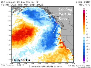
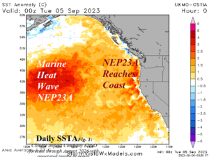
Fig. 2-3: Northeast Pacific SSTA regime and 30-day change.
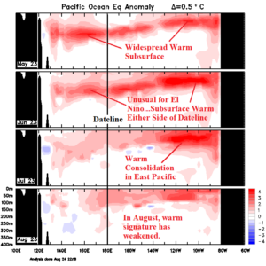
Fig. 4: Equatorial Pacific upper ocean heat during the past 4 months.
Conclusion: El Nino 2023-24 continues to develop and oceanic El Nino is now classified as moderate-to-strong in intensity. The Climate Impact Company constructed analog forecast projects additional strengthening with peak intensity in December followed by weakening early in 2024. El Nino 2023-24 ends by next May and is followed by the return of a weak La Nina later next year. El Nino 2023-24 is not likely to strengthen to levels observed with the most intense El Nino’s on record.