Historic -AO, Strengthening -NAO, Cold Pattern Expands in February for U.S.
01/26/2026, 4:29 am EST
Climate Impact Company Early U.S. Notes
Issued: Wednesday January 28, 2026
Highlight: The “caveat” forecast…a case for regenerating cold.
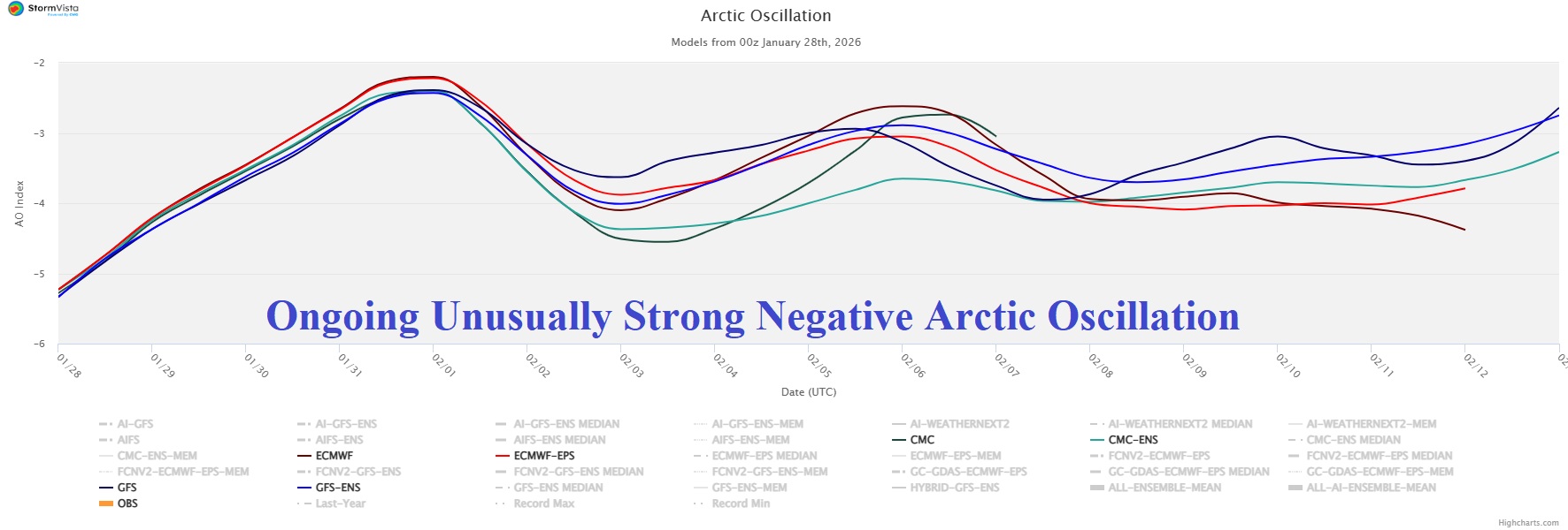
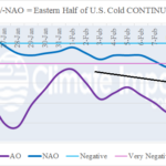
Fig. 1: An ongoing very aggressive negative arctic oscillation based on all models through 16 days.
Discussion: Beginning on January 21st the arctic oscillation (AO) index shifted <-2.0. During the past week AO has averaged -4.0, very supportive of the coldest ending to January in the East U.S. this century. The 15-day forecast indicates -AO continues in the 16-day outlook averaging between -3.5 and -4.0 (Fig. 1). Extended AO forecasts indicate the -AO regime at -2.0 or stronger lasts until February 18th. The 30-day AO index is about -3.6 based on observations and projections for the 30-day period. The AO index of -3.6 is exceeded only twice as a monthly average in the 1950-2026 climatology: -4.3 (FEB-2010) and -3.8 (JAN-1977). Each month produced massive cold air for both the U.S. and Eurasia and similar with the last third of JAN-26. Despite the ongoing -AO, forecast models are generally weakening the cold, especially in the 11-15-day period in the U.S. The question is whether the easing of cold is temporary. In the 11-15-day period, an immense Greenland high-pressure block emerges supported by a strong negative (-2.5 to -3.0) North Atlantic oscillation (-NAO). While the “most likely” day-15 North America temperature anomaly forecast (43% risk) indicates gathering cold in Western Canada while Texas turns warm (Fig. 2), the “caveat” forecast (13% risk) recognizes the lingering -AO and strengthening -NAO and keeps the East very cold (Fig. 3). The other issue of concern is, will lingering -AO and strengthening -NAO enable cross-polar flow of arctic air into North America? 2-meter temperature anomaly forecast skill for the 16-20-day period ranges from a reasonable (for this timeframe) >0.5 anomaly correlation by AI 4CastNet V2 ECM ENS to near 0.3 by the traditional ECM “weeklies” (Fig. 4). The AI 4CastNet V2 ECM ENS chills Western Canada and the U.S. in the 16-20-day period (Fig. 5). Given the potential return to extreme cold which does not match operational forecasts, a recommended strategy is view the day-15 forecast by operational model runs to verify whether cross-polar arctic air is present. The day-15 ECM forecast certainly identifies redeveloping and southward shifting deep arctic air in Canada (Fig. 6). The latest U.S. gas population weight HDD forecasts reveal decelerating heating demand as February arrives (Fig. 7). However, given ongoing -AO through the week of February 19th, are the colder AI projections preferable? Keep in mind, although not perfect, AI forecasts from early January had the very cold forecast for late January easily defeating CFS/ECM outlooks.
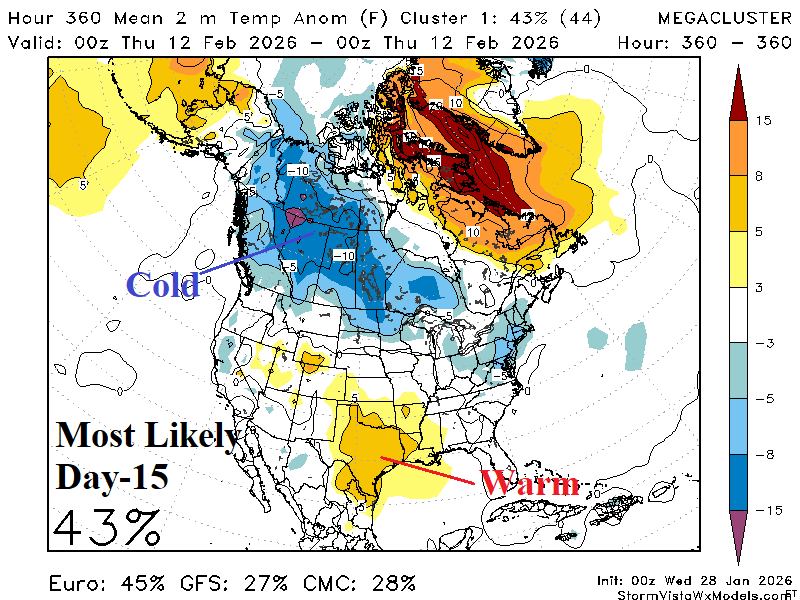
Fig. 2-3: The mega-cluster ensemble “most likely” and “caveat” temperature anomaly forecast for day-15.
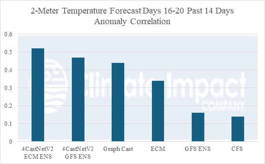
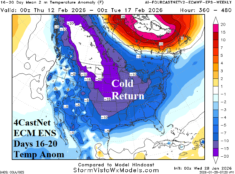
Fig. 4-5: Skill scores by forecast models for 2-meter temperature anomalies during the 16-20-day period from the last 14 days and the 16-20-day North America temperature anomaly outlook by the number 1 model (AI 4CastNet V2 ECM ENS).
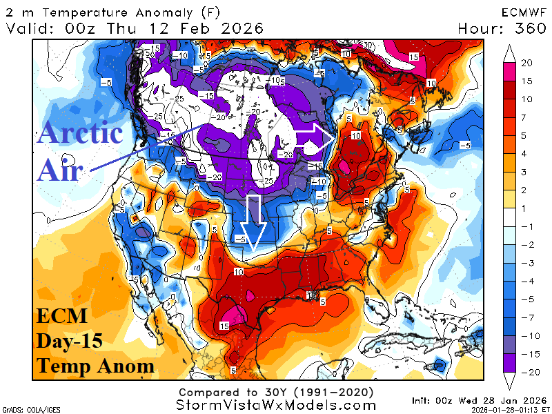
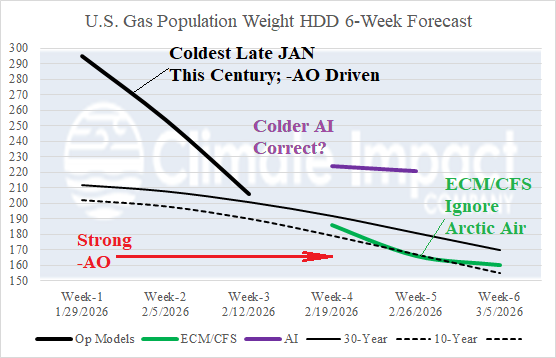
Fig. 6-7: The day-15 North America temperature anomaly forecast by ECMWF and the Climate Impact Company 6-week U.S. HDD projections.