U.S. Storm Update and Long-duration (East) Cold
01/23/2026, 4:43 pm EST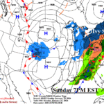
U.S. Winter Storm Update: Over to Mostly Ice Interior Mid-Atlantic Today; 1-2 Feet of Snow New York/New England
01/25/2026, 6:17 am EST
Climate Impact Company Early U.S. Notes
Issued: Saturday January 24, 2026
Highlight: Massive storm is developing, widespread hazards Central and East U.S. this weekend.
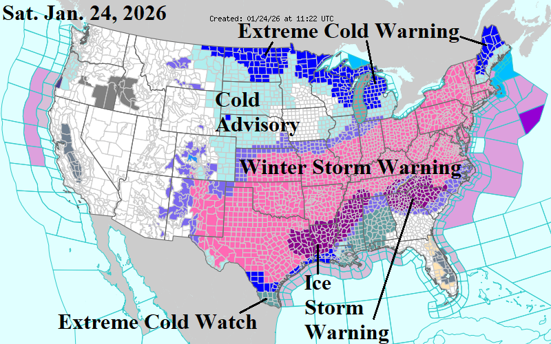
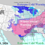
Fig. 1: Latest NOAA/NWS weather watch, warning, and advisories.
Discussion: Winter Storm Warnings have reached the Atlantic Coast and extend westward across Texas and the Southern Great Plains (Fig. 1). Ice Storm Warnings remain in effect from East Texas to Tennessee and Northern Georgia across the western half of South Carolina and Southwestern North Carolina.
The latest NBM snowfall projection for the weekend storm indicates a swath of 6-12 inches from Oklahoma to Ohio (Fig. 2). A few areas will easily eclipse 1 foot of snow in this stretch. Arctic air has arrived in this zone therefore windswept snow drifts of several feet are widespread. In the Mid-Atlantic region, several inches of snow to over 1 foot is likely. However, the snow becomes mixed with sleet about halfway through the storm holding amounts down. The snow becomes “weighty” in this zone (Northern Virginia, Maryland, Delaware, New Jersey) which increases the risk of power outages. Farther north, most of the Northeast U.S. observes all snow with 1-2 feet of snow expected. Blowing and drifting away from the coast will cause piling snow drifts. Near the coast, sleet mixes where power outages are likely. An immense ice storm rides the southern periphery of the precipitation shield.
The NBM ice accretion forecast has increased amounts over the northern half of Louisiana, Northern Mississippi, and Southwestern Tennessee (Fig. 3). In this zone travel is impossible, power outages widespread, and structural damage possible. Ice accretion is also in the dangerous amount zone for Northeast Georgia, the Western Carolinas, and Central North Carolina to Eastern Virginia.
The immense storm has developed across the Southern Great Plains to Texas (Fig. 4). Heavy snow is occurring across the southern half of the Great Plains with a full-throttle ice storm in Southern Oklahoma and the northern half of Texas. Ahead of the arctic front, heavy rain with thunderstorms is expected on the Texas Coast today. 1-1.5 inches of rain near and south of the Houston area is expected and ponding water could freeze instantly once cold air arrives late at night. Right now, Oklahoma City is 7F, Dallas 33F, and Houston 55F.
By Sunday morning, the storm reaches the Atlantic Seaboard (Fig. 5). Snow shifts to sleet and freezing rain in the Mid-Atlantic States while heavy snow spreads across Pennsylvania to southern New England. The arctic front reaches the northwest Gulf Coast. The ice storm continues in the Mid-south States edging northward to Kentucky.
Heavy snow will linger Monday morning across New England (Fig. 6) where snowfall reaches 2 feet in some locations. Sleet affects Cape Cod before precipitation ends as snow.
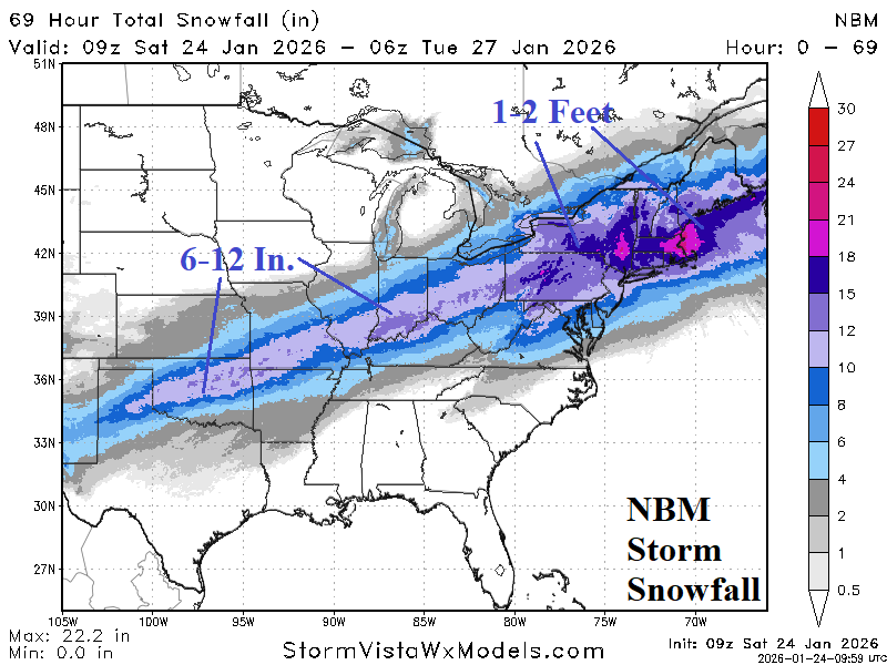
Fig. 2: NBM snowfall forecast for the weekend storm.
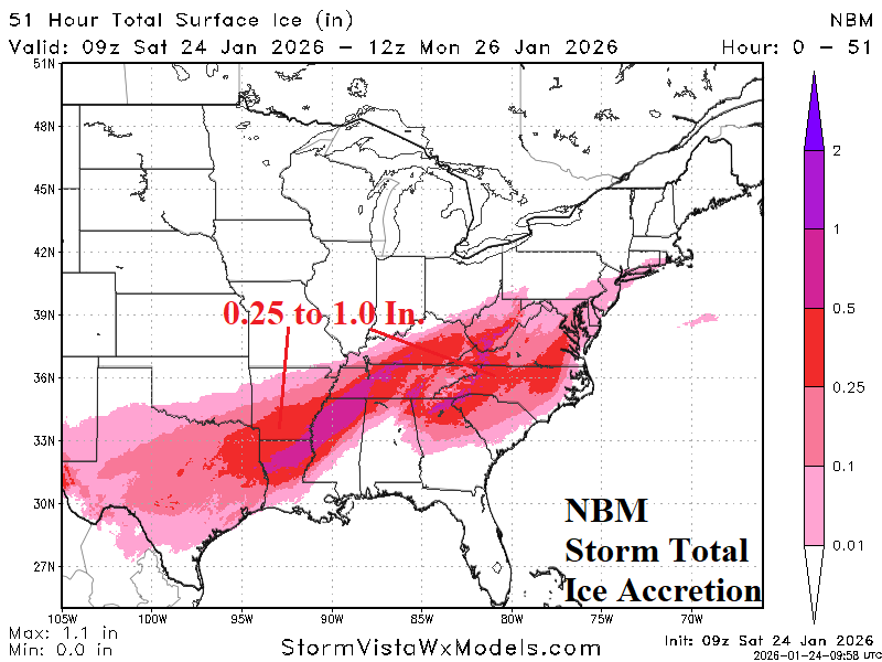
Fig. 3: NBM ice accretion forecast for the weekend storm.
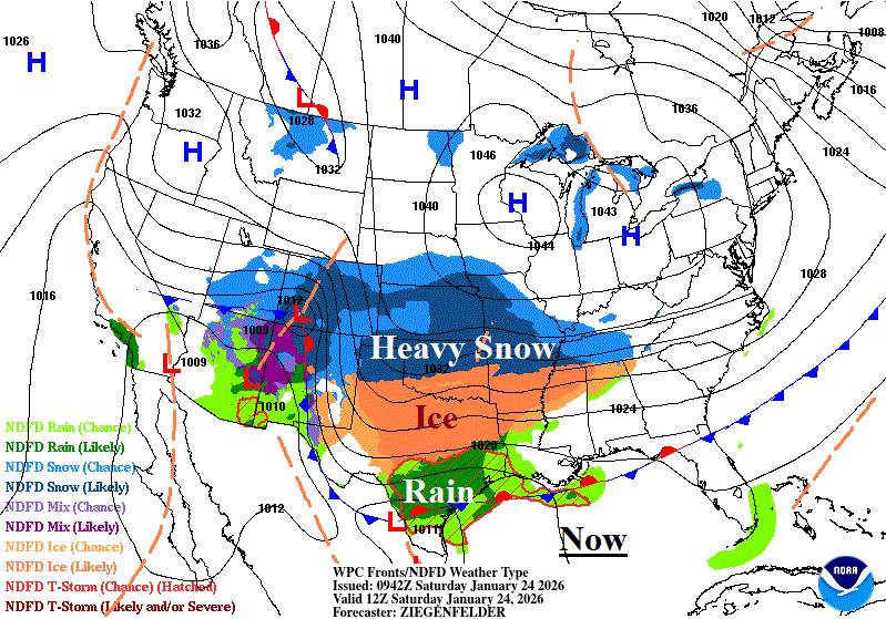
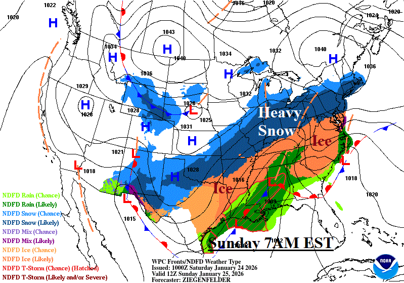
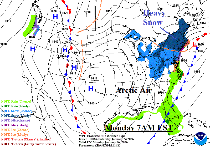
Fig. 4-6: NOAA/WPC storm sequence for the weekend storm.