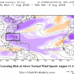
Wind Speed AI Forecasts for North Atlantic Tropics in August
07/31/2025, 8:43 am EDT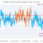
Record Strong Negative (Cool) Pacific Decadal Oscillation Observed in July!
08/06/2025, 2:58 pm EDT
![]()
FINAL Climate Impact Company 2025 North Atlantic Basin
Tropical Cyclone Outlook
Issued: Monday August 4, 2025
Highlight: A dangerous (near the 30-year-normal) season remains indicated.
Executive summary: The FINAL Climate Impact Company 2025 North Atlantic basin seasonal tropical cyclone forecast indicates (after Tropical Storm Dexter) that an additional 12 tropical cyclones will form of which 7 become hurricanes and 4 reach major hurricane strength. The accumulated cyclone energy (ACE) index forecast is 135. The outlook is similar with previously issued outlooks and the latest forecasts from Colorado State University and Tropical Storm Risk/U.K., near the 30-year normal but less active than the 2016-24 active period. The CSU and TSR forecasts are updated August 5-6. A dangerous season remains indicated. The North Atlantic environment is rapidly becoming more supportive for development, typical of early August. The Climate Impact Company hurricane tracks forecast implicates the north/northeast Gulf of Mexico for coastal strikes with near misses on the East Coast.
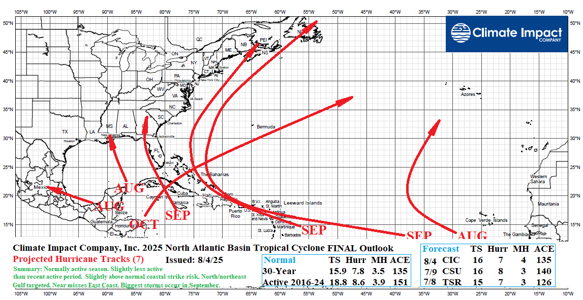
Fig. 1: The updated FINAL Climate Impact Company seasonal activity forecast and projected hurricane tracks for the 2025 North Atlantic basin TC season.
Discussion: Not unusual, is the activation of tropical cyclone season after August 1st. During the recent 2016-24 active period, early season significant tropical cyclones formed in May and June. This year, significant tropical cyclones (forming across the deep tropics) have not (yet) generated. Cited as suppressing factors are dry air in the middle troposphere across the central and western tropical North Atlantic basin, stronger than normal trade winds and above normal sea level pressure, and a tropical Pacific environment conducive to an above normal number of tropical systems in both the Northwest and Northeast Pacific compensated for by subsidence-induced quiet period in the North Atlantic.
Conditions across the North Atlantic basin are improving. The ocean surface and upper ocean heat are warming to levels ranking 3rd warmest for the warm period observed during the past 15 years. Upper shear has eased considerably. A Madden Julian oscillation (MJO) style convection pattern across much of the tropical Pacific during the last 2 months is forecast to shift eastward through the tropical Atlantic and Africa into the middle third of August which should force increased convection currents to help spawn tropical waves. Saharan Dust is expected to ease as tropical West Africa becomes wetter than normal.
ENSO is in neutral phase. Recently, cooling has occurred both at the surface and subsurface of the equatorial Pacific Ocean east of the Dateline. Some forecast models indicate a La Nina return during Q4/2025. Neutral or weak La Nina favors a low-shear upper-level environment across the North Atlantic basin supportive of abundant tropical cyclones.
Forecast: The FINAL seasonal forecast for 2025 across the North Atlantic basin is based on a constructed analog driven by the ocean factors described. The new seasonal forecast is 15.9 (16) tropical cyclones, 7.0 (7) hurricanes, and 4.0 (4) major hurricanes which are very close to the 30-year normal and below the 2016-24 active period normal (Fig. 2). The accumulated cyclone energy (ACE) index forecast (134.9) is also very close to the 30-year normal (134.8) and identifies a 2-in-5 chance the seasonal activity could be higher than indicated and 1-in-5 chance of being considerably lower than forecast (Fig. 3).
Tropical storm Dexter formed overnight therefore the FINAL seasonal forecast includes 12 additional tropical cyclones of which 7 become hurricanes and 4 reach major hurricane intensity (Table 1).
Comparing forecasts from Colorado State University and Tropical Storm Risk/U.K., the Climate Impact Company outlook is similar and very close to the 30-year normal (Table 2). The NOAA/NHC probability forecast range offers higher-upside totals.
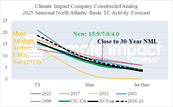
Fig. 2: The Climate Impact Company constructed analog forecast of seasonal tropical cyclone activity for 2025 across the North Atlantic basin.
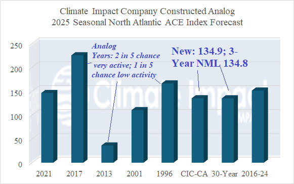
Fig. 3: The Climate Impact Company constructed analog forecast of accumulative cyclone energy index for 2025 across the North Atlantic basin.
| Weight | Tropical Storms | Hurricanes | Major Hurricanes | ACE Index | Coastal Strikes | |
| 1996 | 1 | 13 | 9 | 6 | 166 | 4/2/1 |
| 2001 | 1 | 15 | 9 | 4 | 110 | 3/0/0 |
| 2013 | 2 | 14 | 2 | 0 | 36 | 1/0/0 |
| 2017 | 2 | 17 | 10 | 6 | 225 | 6/3/2 |
| 2021 | 1 | 21 | 7 | 4 | 146 | 6/2/1 |
| Forecast | 15.9 (16) | 7.0 (7) | 4.0 (4) | 134.9 | 4/2/1 | |
| Previous | 16 | 7 | 3 | 137 | 4/3/1 | |
| 2025 | 4 | 0 | 0 | 2.0 | 1/0/0 | |
| FINAL | 12 | 7 | 4 | 132.9 | 3/2/1 | |
| 2016-24 | 18.8 | 8.6 | 3.9 | 151.1 | ||
| 30-Year | 15.9 | 7.8 | 3.5 | 134.8 |
Table 1: The Climate Impact Company FINAL 2025 North Atlantic basin tropical cyclone season activity forecast.
| (30-YR NML) | NOAA | CSU | TSR | CIC |
| Tropical Storms (15.9) | 13-19 | 16 | 15 | 16 |
| Hurricanes (7.8) | 6-10 | 8 | 7 | 7 |
| Major Hurricanes (3.5) | 3-5 | 3 | 3 | 4 |
| ACE Index (135) | 137 | 140 | 126 | 134.9 |
| Final Update | Early August | August 6 | August 5 | Today |
Table 2: The Climate Impact Company FINAL 2025 North Atlantic basin tropical cyclone season activity forecast compared with other forecasters.