Subsurface Equatorial Pacific Looking El Nino-like; Surface and Atmosphere Linger La Nina
02/09/2026, 11:29 am EST![]()
February 2026 Climate Impact Company ENSO Outlook
Issued: Wednesday February 11, 2026
Headline: First summertime El Nino since 2015 in 2026? Maybe!
Executive summary: An organized summertime El Nino affecting U.S. climate has not occurred in 10 years. La Nina or neutral ENSO was present. On average, the JUN/JUL/AUG 2016-25 U.S. climate has averaged hotter than normal (Fig. 1) with above normal rainfall in the Gulf States and much of the East U.S. while a dry bias occupied parts of the Great Plains and Northwest States (Fig. 2). The last full-throttle summertime El Nino was observed in 2015. During that summer, the Midwest States observed cooler than normal climate inspired by heavy rain (Fig. 3-4). Anomalous heat was limited to the Northwest and Southeast U.S., and the Gulf States were drier than normal. Summer 2026 could be an El Nino summer, potentially as strong as 2015. Dynamic models indicate that possibility while a constructed analog keeps ENSO in neutral phase. We’re in the ENSO prediction barrier right now, when ENSO forecast skill is low. Close monitoring of ENSO is required during the next few months.
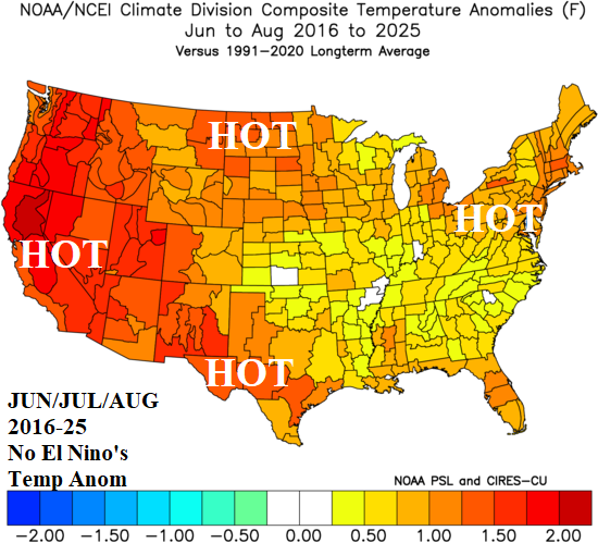
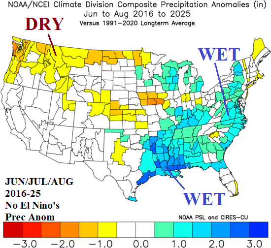
Fig. 1-2: No organized El Nino events during meteorological summer the past 10 years have yielded a hot summer pattern with wet weather in the East.
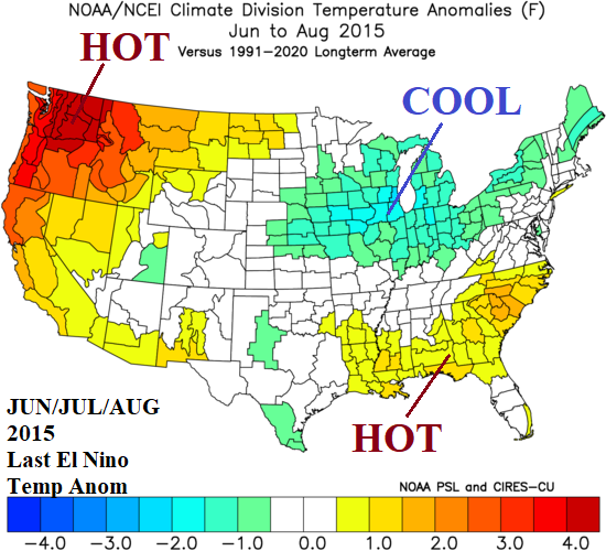
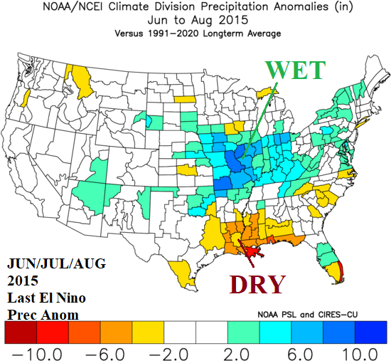
Fig. 3-4: The last full-throttle summertime El Nino brought cool and very wet weather to the Midwest with intense anomalous heat across the Northwest.
Forecast discussion: Two forecast methods are considered: 1. Climate Impact Company constructed analog (CIC-CA) using Nino34 SSTA, and 2. ECM/CFS/POAMA Nino34 SSTA forecasts. The constructed analog clearly identifies the forecast problem by offering confusing results. Demonstrated is the lack of guarantee of ENSO forecasts made during the FEB-APR ENSO prediction barrier when skill is low. Regression of 24 months for Nino34 SSTA was used to produce 5 analogs from the past 30 years. The forecast results indicate a wide range of possibilities from intense El Nino to ongoing weak La Nina (Fig. 5). The outlook extends to 2027 and indicates 2026 El Nino/La Nina regimes flip in 2027. The consensus of all scenarios yields neutral ENSO through 2027. However, the most likely analog should emerge during FEB-APR enabling an accurate prediction, using the CIC-CA method, by mid-to-late northern hemisphere spring.
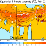
As described in the Climate Impact Company Weekly ENSO Diagnostics Report issued earlier this week, current observations yield 2 extremes. In the subsurface, two Kelvin Waves have caused significant warming across the length of the equatorial Pacific Ocean. Usually, significant warming of the subsurface – if sustained – signals El Nino ahead. Support for 2026 summertime El Nino is (definitely) observed now. However, the atmosphere is not responding. The Nino34 SSTA remains at the La Nina threshold, southern oscillation index (SOI) and multi-variate ENSO index (MEI) are well within La Nina criteria. The subsurface warming must engage the atmosphere to produce lighter trade winds to allow the ocean surface in the tropics to warm. This process is likely caused by an active Madden Julian oscillation (MJO) shifting across the tropical Pacific not expected for a while.
Meanwhile, traditional dynamic models from the Australia Bureau of Meteorology, ECMWF, and NOAA each forecast a strong El Nino by northern hemisphere summer (Fig. 6). The aggressive El Nino forecasts are likely in response to the subsurface warming.
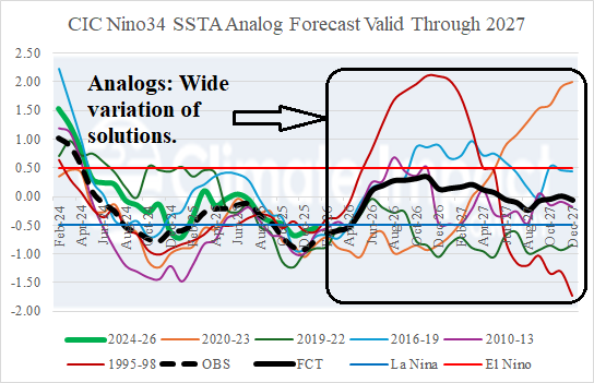
Fig. 5: The Climate Impact Company Nino34 SSTA constructed analog forecast through 2027. A large disparity of potential scenarios as we enter the ENSO prediction barrier common during FEB-APR. Clarity is expected by APR/MAY.
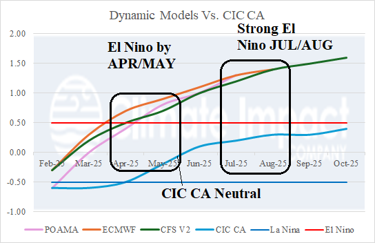
Fig. 6: A collection of traditional dynamic forecast models indicates the Nino34 SSTA warms to a full-throttle El Nino by northern hemisphere summer.