NOAA Long-lead Probability Climate Forecast Implicate Florida for Hurricane Risk in August
07/18/2024, 11:28 am EDTNeutral ENSO Continues, Some Cooling NW Coast of South America
07/22/2024, 11:24 am EDTHighlight: Western heat severe at times; Northeast U.S. Corridor hot and VERY humid. Thundery Texas. Florda TC’s later August.
Charts of the day: Catalyst to West and South/East U.S. heat.
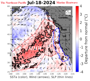
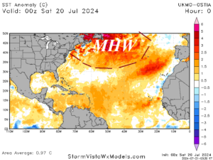
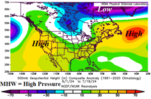
Discussion: Regions of very warm ocean water known as marine heatwaves (MHW) are commonly linked to high pressure in the upper atmosphere which cause a dry and warmer than normal climate. MHW’s are present and quite strong off the U.S. West Coast and south of the Canadian Maritimes. Aloft, high pressure centered on the U.S. West Coast and just east of the Northeast U.S. are semi-permanent features causing the extreme heat and drought development in the West U.S. and anomalous heat with extremely high humidity in the South and East U.S.
Week-2 Ahead Forecast valid July 28-August 3, 2024: Northeast heatwave.
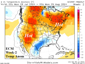
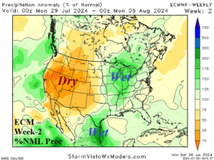
Discussion: The upper ridge associated with the Northeast Pacific MHW budges inland sustaining the West U.S. heat and dryness but off the immediate coast. The upper ridge associated with the MHW southeast of Canada amplifies over Nova Scotia leading to a hot regime across the Northeast States, possibly record heat. Texas to the Midwest is affected by frequent gully-washer thunderstorms.
Week-3 Ahead Forecast valid August 4-10, 2024: West and Northeast heatwaves.
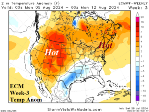
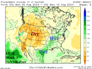
Discussion: Upper ridge sprawls from the West U.S. to the Canadian Maritimes and New England States. The result is anomalous heat continuing in the West where drought is strengthening quickly. Additionally, the Northeast States stay hot with unusually high humidity! Texas to Ohio Valley thunderstorms continue.
Week-4 Ahead Forecast valid August 11-17, 2024: Western heat and Texas rains continue.
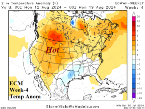
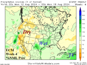
Discussion: High pressure ridging is shifting north during mid-August. Weak low pressure sustains the Texas wet pattern. The tropics are becoming active.
Week-5 Ahead Forecast valid August 18-24, 2024: Tropical cyclone risk in Florida. West/Northeast heat continues.
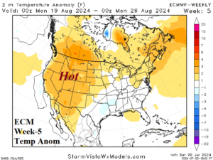
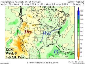
Discussion: The upper ridge anchors on the Northwest U.S. and Nova Scotia where hot and dry risk is highest. Focus is shifting to the tropics where Florida is potentially targeted by tropical cyclones.