Is Upper Air Pattern Associated NAWH Inhibiting TC Season?
09/08/2025, 5:44 am EDT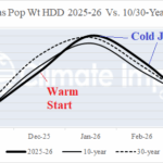
Initial 2025-26 U.S. Heating Season Gas Population Weight HDD Forecast
09/15/2025, 5:04 am EDT![]()
September 2025 Climate Impact Company ENSO Outlook
Issued: Thursday September 11, 2025
Highlight: Short-lived La Nina ahead. Vigorous marine heatwave reaches West Coast of North America. If persistent, could initiate El Nino in 2026.
Executive summary: A short-lived La Nina is ahead and supported by vast cooling of the subsurface equatorial East Pacific during recent weeks. However, if the warming Northeast Pacific persists in early 2026, the La Nina episode ends, possibly abruptly and the warm waters of the Northeast Pacific spread south possibly causing an El Nino onset middle third of 2026 which could become intense later next year.
Discussion: Possibly the strongest marine heatwave (MHW) on record has shifted across the Northeast Pacific to the North America West Coast (Fig. 1). The 2021-2025 super anomalous warm water off the East Asia Coast extending eastward to just past the Dateline fueling the strongest and lengthiest cool phase of the Pacific decadal oscillation (-PDO) has shifted rapidly eastward reaching the North America West Coast during the past 2-3 weeks. The event features the merging of previously separate MHW’s NEP25A and NEP25B. The strongest MHW on record in the Northeast Pacific occurred during 2013-15. Eventually, the anomalous warm water, which raised havoc on Northeast Pacific marine life, shifted south into the East Pacific tropics causing one of the strongest El Nino episodes on record (Fig. 2-3).
The warm water shift to the North America West Coast suggests the ending of the 2020-25 record strength -PDO regime which, according to NOAA, reached record strength during JUN/JUL/AUG in the -3 to -4 range. The -PDO regime of 2020-25 is driven by the extent of warm waters in the west and central portion of the North Pacific rather than cool waters of the Northeast Pacific as with prior -PDO regimes.
The Climate Impact Company constructed analog Nino34 SSTA forecast reveals a confident projection of short-term La Nina to end 2025. The analog years are split on whether ENSO returns to La Nina or El Nino generates later in 2026 (Fig. 4). If the MHW presence developing now lasts through 2026, the robust El Nino solutions will generate.
Interestingly, the North Atlantic warm hole (NAWH) phenomenon which vividly reappeared in 2025, became intense during the 2014-15 presence of the Northeast Pacific MHW. The combination of the Northeast Pacific MHW and NAWH regime was causal to the Alaska “ridge bridge” and downstream “polar vortex” pattern of North America winter seasons in 2013-14 and 2014-15 (Fig. 5-6).
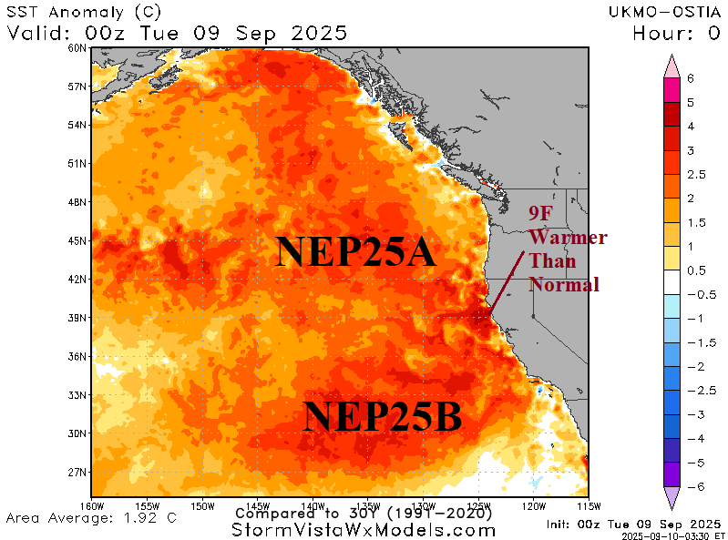

Fig. 1-2: Marine heatwave NEP25A and NEP25B combine in the Northeast Pacific and emergence of the 2014 MHW in the Northeast Pacific.
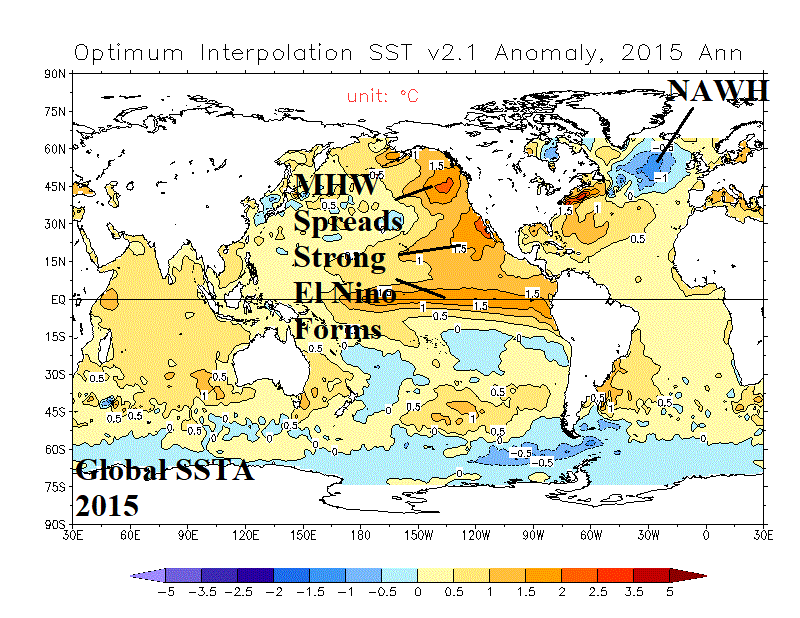
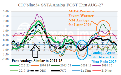
Fig. 3-4: The MHW spreads south causing an intense El Nino in 2015 and the Climate Impact Company constructed analog Nino34 SSTA forecast into 2027.
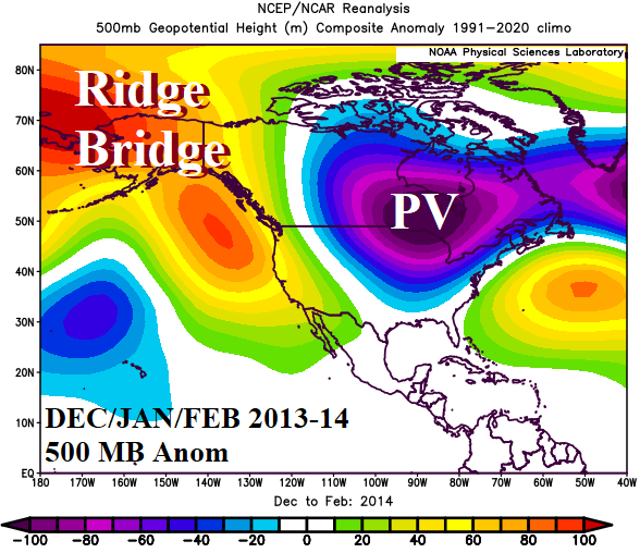

Fig. 5-6: The North America 500 MB anomaly pattern for meteorological winter 2013-14 and 2014-15.

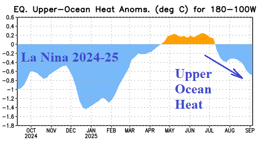
Fig. 7-8: The cooling subsurface in the eastern equatorial Pacific Ocean supportive of La Nina ahead.

Fig. 9: Operational models Nino34 SSTA forecasts are agreeable on La Nina to end 2025.