North Atlantic Basin SSTA Status: Still Much Warmer Than Normal!
09/30/2024, 12:52 pm EDTHWRF (and HMON) Bring Milton to a Strong Category-4 Major Hurricane in Eastern Gulf Wednesday
10/05/2024, 4:52 pm EDT
Fig. 1: The NOAA/CPC rainfall amount analysis during Sep. 22-28, 2024.
Discussion: The NOAA/CPC Sep. 22-28 rainfall amount observation analysis across the U.S. (Fig. 1) identifies the excessive rain associated with Category-4 Major Hurricane Helene. Note the influence of topography on the observation results. Near and just east of landfall, 8-12 in. of rain was observed. Helene was moving at 30 mph while making landfall keeping rainfall totals below normal totals at landfall for a category-4 major hurricane. However, note the effect on rainfall totals by the interaction of Helene and the Southern Appalachian topography. A large area of 8-12 in. of rain was observed mainly on the east side of the mountain ranges piling to 16-20 in. just south of Asheville, NC. The upper-level trough guiding Helene northward entrained tropical moisture causing 4-6 in. of rain across Tennessee and Kentucky.
The morning weather satellite view of the North Atlantic basin reveals powerful Hurricane Kirk, likely a major hurricane within 24-36 hours and turning north in the outer North Atlantic (Fig. 2). Kirk is followed by Tropical Disturbance 91L likely to become a hurricane while following Kirk by this weekend. Two areas of tropical convection require monitoring for development in the Bay of Campeche and in the western Caribbean Sea. The upper shear axis across the west and north Gulf of Mexico is immense and likely to prevent any short-term tropical development.
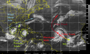
Fig. 2: North Atlantic basin weather satellite view.