Deep Layer Soil Moisture Anomalies Drying…Central Brazil Drought Strengthening
11/24/2023, 12:56 pm ESTBitter Cold Northwest Eurasia and Into Europe; Doubting Major Warm-up to Follow
11/28/2023, 3:57 pm EST


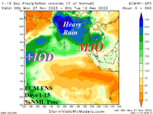
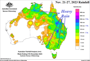
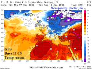
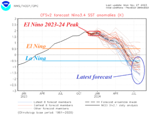
Fig. 1-4: The 15-day percent of normal rainfall forecast by ECM ENS for India/Southeast Asia, past 7 days rainfall amount in Australia, GFS 11-15-day temperature anomaly forecast for Europe, and the NCEP CFS V2 Nino34 SSTA forecast into next year.
Discussion: A heavy rainfall regime is ahead for the first half of December across much of India and Southeast Asia. Heavy rain in this region during El Nino is unusual. Presence of the convection phase of Madden Julian oscillation (MJO) crossing the positive phase Indian Ocean dipole (+IOD) inspired warmer than normal waters through the eastern tropical Indian Ocean is a likely catalyst for the heavy rainfall episode. Meanwhile, expectations of El Nino-inspired Eastern Australia drought are failing. Last week, several areas reported up to 7-8 in. of rain in Queensland. The heavy rainfall pattern in Eastern Australia lasts another 7-10 days. Typically, El Nino produces stronger than normal westerlies in the northern mid-latitudes yielding maritime-inspired milder winter climate across the U.S. and Europe. However, meteorological winter begins with expanding and strengthening cold in Europe. In the 11-15-day forecast, piling snow across Northwest Eurasia leads to arctic air development. Oceanic El Nino is strong but atmospheric El Nino is weaker, helping to explain why some of these unexpected weather regimes are occurring. Interestingly, the strong oceanic El Nino signature is forecast to fade fast in early 2024. The latest 8 ensemble members of the NCEP CFS V2 Nino34 SSTA forecast indicate strong La Nina by July of 2024. Strong (oceanic AND atmospheric) El Nino episodes are typically followed by La Nina one year later.
