NOAA Updates Long-lead Climate Forecasts
02/20/2025, 9:26 am EST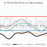
Changeable Nino SSTA Due to Madden Julian oscillation; La Nina Weakens Again
02/24/2025, 9:32 am EST
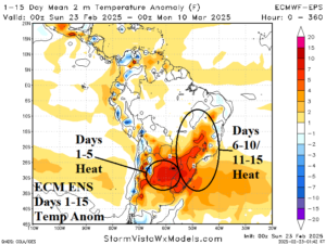
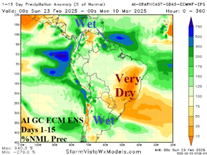
Fig. 1-2: The ECM ENS 15-day temperature anomaly forecast across South America plus the 15-day percent of normal rainfall outlook from Graph Cast.
Discussion: Pattern change is ahead for South America inspired, in part, due to the warming Nino12 SSTA off the northwest coast of South America. Argentina is much hooter than normal this week (Fig. 1). However, incoming thunderstorms will suppress the heat risk and wet weather will persist through the 15-day period (Fig. 2) while anomalous heat and dryness increase intensity across Eastern Brazil.
The weekend trend is to maintain a chilly pattern in the Black Sea region and eastward through the medium range according to ECM (Fig. 3). Consequently, an upper ridge over Europe maintains presence and blocks any eastward progression of wet weather affecting the West Coast of Europe. The AI Graph Cast 15-day percent of normal precipitation forecast is drier than normal across the East Europe/West Russia drought area (Fig. 4). Other models (GFS) are progressive with the wet weather and push precipitation across Central Europe in the medium range.
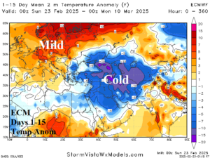
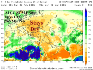
Fig. 3-4: The ECM 15-day temperature anomaly forecast across Europe and Western Russia plus the Graph Cast percent of normal precipitation outlook.
In Australia, the past week was mostly drier (Fig. 5) and cooler than normal. Re-emerging heat and dryness will affect the entire continent this week. However, during the medium range Eastern Australia turns very wet (Fig. 6). Potential for impacts from a tropical cyclone are apparent for early next week while much of the North turns generally eater than normal in the 8-14/11-15-day period.
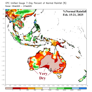
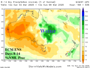
Fig. 5-6: The 7-day percent of normal rainfall observations across Australia for the past week