The SEP/OCT/NOV North Atlantic TC Outlook Versus Normal
08/30/2024, 9:00 am EDTTropical Africa Becomes Soaking Wet and Emits Strong Tropical Waves into the Atlantic
09/04/2024, 11:04 am EDT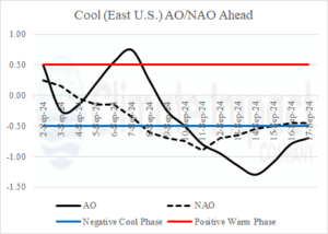
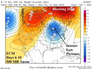
Fig. 1-2: The AO/NAO 16-day forecast, and ECM 6-10-day upper air outlook indicate a cool burst centered on the Midwest U.S. during the 6-10-day period.
Discussion: As early September arrives, most striking, is the cool weather set-up in the Midwest/East U.S. centered on the 6-10/8-12-day period. At that time, both the arctic oscillation (AO) and North Atlantic oscillation (NAO) shift to negative phase (Fig. 1) supporting a high latitude blocking ridge and amplified polar vortex centered on Ontario and the Great Lakes (Fig. 2). The upper trough is cold enough to bring risk of <32F to Ontario and parts of Quebec (Fig. 3). The -AO/-NAO pattern also supports above normal strength westerly flow across the Eastern U.S. (polar Jetstream) and Northern Florida (subtropical Jetstream) promising to keep any tropical cyclones approaching the Southeast/East U.S. out-to-sea (Fig. 4) during the climatological peak of tropical cyclone activity centered around September 10th. However, close eyes are on the southern Gulf of Mexico for a possible significant tropical cyclone as the middle third of September arrives.
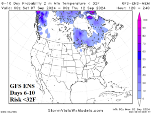
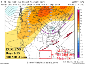
Fig. 3-4: The GFS ENS 6-10-day <32F risk forecast and 15-day ECM ENS 500 MB anomaly outlook.
In the short-term, an Excessive Heat Watch has been issued for the Southwest U.S. including all Southern California except for the immediate coast (Fig. 5). Inland temperatures extend to 104-108F peaking late week including a 100F risk reaching the Burbank area at that time. Las Vegas reaches 108F and Phoenix 114F on Thursday. Widespread Red Flag Warnings for elevated fire risk are issued for the Northern Great Basin to the Snake River Basin and northwest Great Plains. An early season chill in New England brings a frost threat to Interior New York tonight. Dense fog covers the Tennessee Valley, and a Flood Watch is posted for west-central Texas for heavy rain today. The 5-day rainfall outlook keeps most of the wet pattern this week in the Gulf of Mexico except for WED/THU/FRI across the Southeast U.S. (Fig. 6).
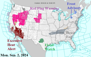
Fig. 5: NOAA/NWS weather watch, warning, and advisory areas.
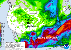
Fig. 6: NOAA/WPC 5-day quantitative precipitation forecast.
The U.S. population weight CDD forecast indicates cools to near the 30-year normal over the next 2 weeks (Fig. 7).
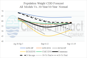
Fig. 7: U.S. population weight CDD forecast utilizing all models, their consensus, and comparing with 24 hours ago plus the 30-year/10-year normal.