Suddenly, Nino34 SSTA is Cooling. Some Models Forecast La Nina Ahead
07/17/2025, 12:40 pm EDT
July 2025 ENSO Outlook: Making the case for weak La Nina in quarter 4/2025.
07/24/2025, 5:23 am EDT
Climate Impact Company Tropical Feature
Issued: Sunday July 20, 2025
Highlight: North Atlantic tropics not as warm as last year but still quite warm. Nino34 SSTA is cooling. La Nina ahead for Q4/2025? Busy and dangerous AUG/SEP/OCT ahead for tropical cyclones.
| First Hurricane (after June 1st) | Tropical Storms | Hurricanes | Intense Hurricanes | |
| 2016 | Earl Aug. 2-6 | 10 | 5 | 4 |
| 2017 | Franklin Aug. 7-10 | 11 | 9 | 6 |
| 2018 | Beryl (July 4-15) | 13 | 7 | 2 |
| 2019 | Barry (July 11-16) | 16 | 5 | 3 |
| 2020 | Hannah (July 23-26) | 22 | 13 | 7 |
| 2021 | Elsa (June 30-July 9) | 16 | 6 | 4 |
| 2022 | Bonnie (July 1-9) | 12 | 8 | 2 |
| 2023 | Don (July 14-24) | 15 | 6 | 3 |
| 2024 | Beryl (Jun 28-July 9) | 16 | 10 | 4 |
| 2025? | ||||
| Average | July 14 | 14.6 | 7.7 | 3.9 |
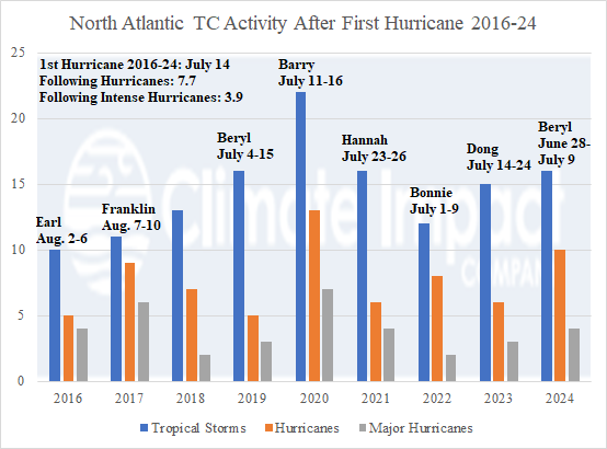
Table 1: North Atlantic basin tropical cyclone activity after the first hurricane 2016-24.
Discussion: The Operational GFS and ECM forecast models are not projecting hurricane threats through their 15-day forecast period which brings us to August 4th without a hurricane so far during the 2025 season. Since 2018, the season’s first hurricane occurred prior to August 1st and during the 2016-24 active period (seasonal activity about 30% higher than the 30-year normal) the average date of the first hurricane is July 14th (Table 1). The primary catalyst to the 2016-24 active period is the warm to very warm North Atlantic basin, especially in the tropics as defined by the tropical North Atlantic (TNA index (Fig. 1). After the first hurricane, during the 2016-24 active period, a dangerous average of 7.7 hurricanes and 3.9 major hurricanes are observed. NOAA is forecasting 6-10 hurricanes and 3-5 major hurricanes for 2025 therefore anticipated is another busy and dangerous August to October. Colorado State University, Tropical Storm Risk U.K., and Climate Impact Company are slightly on the lower end of the NOAA probability forecast citing the slightly less warm North Atlantic compared to recent years (Fig. 2). The Main Development Region for North Atlantic hurricanes has warmed to +0.48C recently although considerably cooler than 1 year ago. Similarly, the Caribbean Sea (+0.35C), and Gulf of Mexico (+0.52C) each have warmed slightly in July but are much cooler than 1 year ago. The regional SSTA cited are much cooler than last year although still historically quite warm, ranking in the top 5 warmest all-time. A recent concern is the sudden cooling of the Nino34 SSTA (Fig. 3). Are we shifting toward La Nina for Q4/2025? If so, the upper end of the NOAA seasonal probability forecast will be realized.
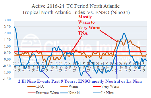
Fig. 1: The tropical North Atlantic (TNA) index and Nino34 SSTA ENSO phase for the 2016-24 active period.
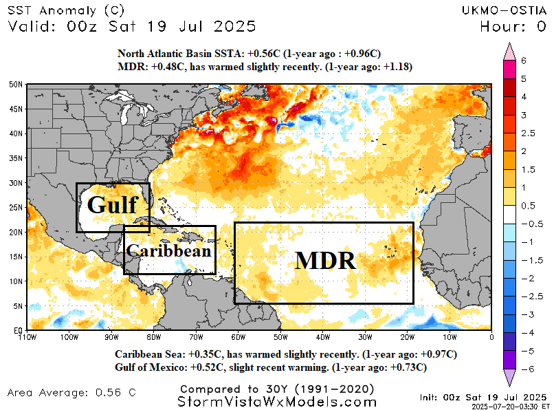
Fig. 2: The North Atlantic basin and regions associated with tropical cyclones daily SSTA analysis.
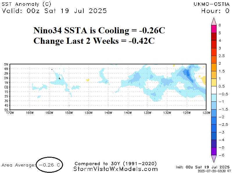
Fig. 3: Suddenly, the Nino34 SSTA is cooling.

