Summer 2024-25 Focus on Evolving Drought Interior East Australia.
10/15/2024, 7:52 pm EDTNew TC Alert Posted for Central/East Caribbean Sea for Late October
10/21/2024, 8:28 am EDTExecutive summary: Marine heat waves continue to produce significant influence on where semi-permanent high-pressure areas form alongside their compensating low-pressure areas. Many MHW’s are ongoing in the northern hemisphere, the strongest east of Japan. Regenerating MHW’s are likely during the southern hemisphere summer in the subtropical/middle latitude oceans. The extensive warming of the ocean caused by MHW’s is likely suppressing La Nina onset.

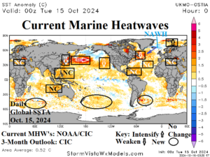
Fig. 1: Global marine heat waves identified by NOAA and CIC and 3-month projection by CIC (Valid January 2025).
Discussion: According to NOAA (from their September analysis), global marine heat wave (MHW) aerial coverage is decreasing to about 31% with additional decrease to 27% expected later in the year. The 31% value ranks 14th of the past 30 years, which is remarkable given the persistent middle 2024 monthly observations of the second warmest ocean surface on record. NOAA cites La Nina development as a contributor to MHW decline. Climate Impact Company disagrees with the NOAA assessment. Northern hemisphere MHW’s may weaken slightly but overall, most global SSTA forecasts maintain their intensity and add new MHW’s across much of the subtropical/mid-latitude southern hemisphere in the coming months. The warmer oceans are likely defeating La Nina onset.
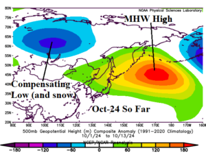
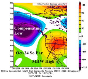
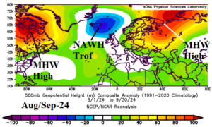
MHW’s had a dominant role on upper air high-pressure ridge patterns into the northern hemisphere autumn season. Included is the titanic upper ridge east of Japan across the strongest current MHW (Fig. 2). Note in October, the compensating trough over East-central Russia causing above normal early season snow cover. Downwind the Northeast Pacific MHW a titanic upper ridge rests over the West U.S. in October so far (Fig. 3). Compensating Gulf of Alaska low-pressure has recently generated. Famously, the Norwegian and Mediterranean Sea MHW’s were well-correlated to AUG/SEP-24 strong upper ridge patterns across Western Russia and the Black Sea region leading to a drought (Fig. 4). The MHW off Newfoundland coupled with warm SSTA in Hudson Bay spawned an intense northeast North America high pressure area mid-to-late summer. The North Atlantic warm hole (NAWH) low pressure area located west of Europe.


Fig. 2-4: Global marine heat waves and recent attendant upper-level high pressure ridge areas.
