Northern Hemisphere Snow Cover Trend During Cold Season
09/05/2024, 12:49 pm EDTDaily Feature: The Over-achieving Sun!
09/08/2024, 9:22 am EDT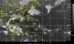
Fig. 1: North Atlantic basin weather satellite view.
Discussion: The remarkably quiet North Atlantic basin tropical regime (Fig. 1) continues as the peak of season arrives by early next week. Tropical Disturbance 90L southeast of Houston is forecast to roam southeast and southwest over the next few days and as an organized low-pressure area moving across warm western Gulf waters has a chance to strengthen although NOAA/NHC maintains a low risk (10%). Subtropical Disturbance 99L southeast of New England will gain strength moving north-northeast and into Nova Scotia later this weekend. A tropical low moving across the southern Yucatan Peninsula is likely to weaken. At 600 MB moisture is very low based on the Sep. 1-3 relative humidity anomaly analysis (Fig. 2). The low RH explains why the deep tropics are silent regarding any tropical waves. However, RH is buoyant in the subtropics although too far north (except for the Gulf of Mexico) to help inspire tropical development.
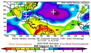
Fig. 2: The North Atlantic subtropics/tropics 600 MB relative humidity anomalies.