Summer 2023 CDD’s are not impressive (mixed demand from region-to-region across U.S.)
08/03/2023, 7:25 pm EDTWhy So Many Severe Weather Reports Past 2 Months?
08/08/2023, 5:26 am EDTNew 2023-24 ENSO outlook is issued by tomorrow.

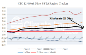
Fig. 1: The 12-week Nino SSTA region tracker indicates moderate-strength oceanic El Nino.
Discussion: The weekly Nino SSTA regions indicate moderate El Nino (Nino34 = +1.1C) weakened slightly last week and is moderate intensity (Fig. 1). Waters off the northwest coast of South America (Nino12 = +3.4C) are record warm and additional warming occurred last week. Interestingly, a Modoki index of -1.1C is present as only weak El Nino warming has reached the Dateline while areas to the east have a robust warm El Nino signal. The atmospheric El Nino is lagging oceanic El Nino. However, a tendency for stronger El Nino-like negative southern oscillation index has appeared during the last 3 weeks. Onset of an El Nino climate is expected by Sep. 1st.

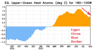
Fig. 2: The upper ocean heat east of the Dateline through the equatorial Pacific.

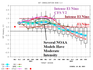
Fig. 3: NOAA ENSO forecast models.
The subsurface equatorial Pacific upper ocean heat has diminished during the past month (Fig. 2). The cooling is present in the 150-300-meter layer at the Dateline eastward to 140W. Robust warmth supportive of El Nino is present at about 130W and eastward to the northwest coast of South America. An unlikely trend given a developing El Nino episode.
NOAA ENSO forecast models continue to show uncertainty regarding El Nino 2023-24 strength. The NCEP CFS V2 remains the most aggressive forecast while several other models maintain the current moderate intensity with no additional strengthening (Fig. 3). Note that a reversal to La Nina is indicated for the middle of 2024.
