HWRF (and HMON) Bring Milton to a Strong Category-4 Major Hurricane in Eastern Gulf Wednesday
10/05/2024, 4:52 pm EDTSouthwest Europe and Black Sea Heavy Rains
10/10/2024, 4:33 am EDT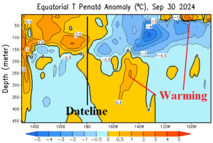
Fig. 1: The subsurface equatorial East Pacific has produced some warming during the past 1-2 weeks suggesting an expected La Nina onset in late 2024 is delayed or does not occur.
Discussion: The subsurface equatorial East Pacific cooled to a peak previously observed last April during the late AUG/early SEP timeframe. However, the second spike in cooling has receded. The equatorial East Pacific subsurface has warmed through the upper 20 meters of the ocean off the northwest coast of South America and below 200 meters in the Nino4/Nino34 regions (Fig. 1). The daily Nino34 SSTA is close to the La Nina threshold (-0.45C) while near the Dateline, the Nino4 SSTA is slightly warmer than normal (+0.21C).
The U.S. 15-day forecast via all operational models remains very dry across majority of crop areas. Forecast models bring “normal” rainfall to the Midwest and Mid-south U.S. late in October (Fig. 2). The weather pattern is steadily warmer than normal.
A wet pattern is ahead in South America. The ECM week-2 outlook valid for next week indicates two areas of heavy rain (Fig. 3). One area is in Argentina and the second across central/northeast Brazil. Both zones are encountering drought and need rainfall. ECM indicates gradual regeneration of a drier pattern holding off until November.
GFS introduces an area of heavy rainfall in the 6-10-day period across New South Wales while a confident 5-day forecast reveals heavy rain on the Queensland Coast (Fig. 4). Other models are drier in the 6-10-day period. In Europe, high wind and heavy rain episode in the short-term in-part due to the remains of a tropical cyclone. The upper trough producing this week’s storminess is emitted eastward to bring wet weather to the Black Sea region next week according to ECM (Fig. 5).
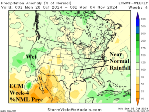
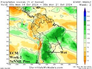
Fig. 2-3: ECM week-4 percent of normal rainfall across the U.S. and the week-2 percent of normal rainfall outlook across South America.
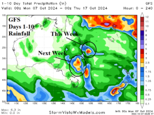
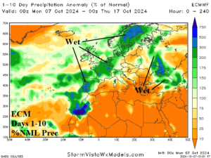
Fig. 4-5: GFS 10-day rainfall amount forecast for Australia and the 10-day percent of normal rainfall forecast by ECM for Europe.