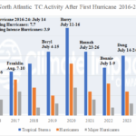
First North Atlantic Hurricanes 2016-24 and Following Activity
07/20/2025, 9:30 am EDT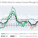
July 2025 ENSO, PDO, AMO, and IOD Analog Forecasts
07/28/2025, 12:14 pm EDT![]()
July 2025 Climate Impact Company ENSO Forecast
Issued: Thursday July 24, 2025
Highlight: Making the case for weak La Nina in quarter 4/2025.
Executive summary: Some forecast models have insisted that weak La Nina redevelops by quarter 4/2025. Diagnostics confirm the La Nina potential. During recent weeks a traditional cool phase Pacific decadal oscillation has formed and the attendant atmospheric wind is driving cool waters off the U.S. West Coast toward the tropics south and southwest of Hawaii. Upper ocean heat has suddenly cooled. If the current trend persists, weak La Nina could emerge by northern hemisphere mid-autumn.
Discussion: The “Mantua Box” located in the west-central to east-central North Pacific Ocean is an exceptionally warm +2.31C entering late July (Fig. 1). When compared to waters off the West Coast of the U.S., which are exceptionally cool (Fig. 2), a robust cool phase of the Pacific decadal oscillation (-PDO) is apparent. The -PDO pattern has persisted during this entire decade. However, a traditional warm central Pacific/cool northeast Pacific -PDO is developing for the first time. This observation is important as the attendant atmospheric pattern (Fig. 3) is pushing the cool waters southwestward toward the Nino4/Nino34 SSTA regions which are cooling. In fact, the upper ocean heat in the eastern equatorial Pacific is suddenly responding shifting cooler in recent days (Fig. 4-5). The cooling trend identified increases support of some forecast models forecasting a shift to La Nina during the next 1-3 months (Fig. 6-7).
ENSO phase forecasts is difficult during the past couple years as El Nino and La Nina tendencies appear and then fade. The current cooling shift is likely related to a lengthy Madden Julian oscillation (MJO) convection phase persisting in the western equatorial Pacific Ocean, similar with an El Nino signature, eventually causing trade winds in the eastern equatorial Pacific to increase and force cooling at the surface and subsurface. The MJO forecast is weakening eastward progression which could temporarily ease the recent cooling ENSO observations. However, the long-term MJO forecast is for a return of the signature witnessed during mid-year which would regenerate the La Nina tendency.
Summary: A tendency toward La Nina has developed due to a strengthening traditional -PDO, cooling in the Nino34 SSTA region, and loss of previously observed upper ocean heat in the eastern equatorial Pacific. Although this trend may be interrupted by a transient MJO, a return to the cooling trend is expected by the second half of August. If so, the ENSO phase will shift toward weak El Nino during quarter 4/2025 as indicated by some forecast models.
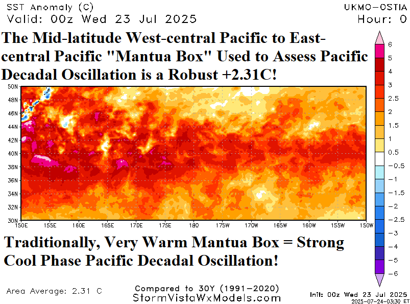
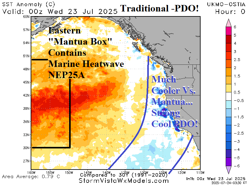
Fig. 1-2: Traditional cool phase Pacific decadal oscillation occurs when the central Pacific “Mantua Box” is warm and waters off the West Coast are cool.
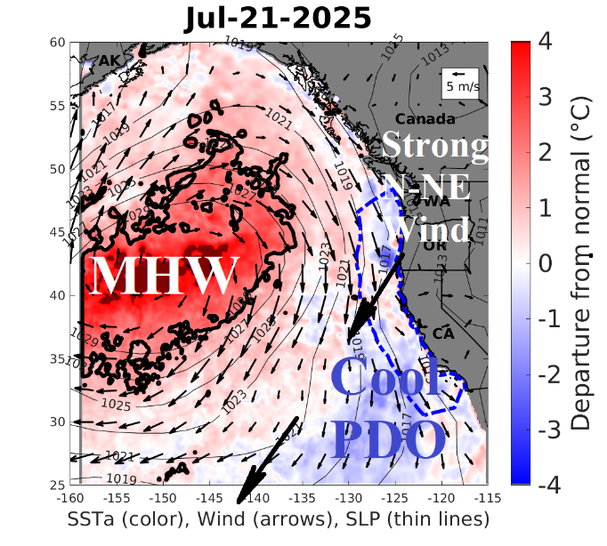
Fig. 3: Strong north-northeast wind flow forms between the marine heat wave and cool PDO waters off the West Coast pushing cooler water toward the tropics.
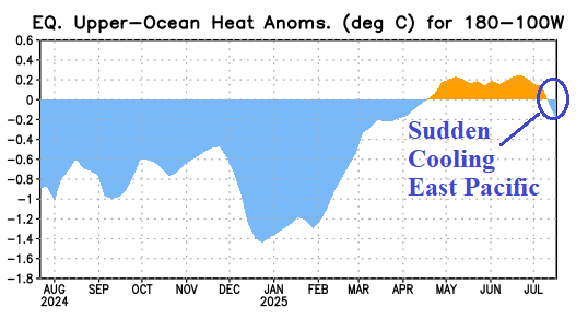
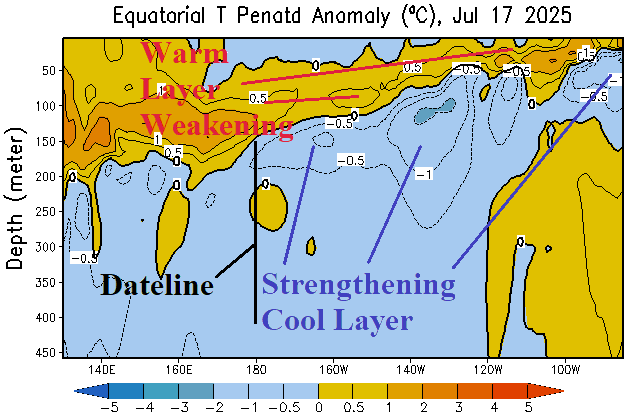
Fig. 4-5: The upper ocean heat in the equatorial East Pacific has suddenly started to cool as the shallow warm layer erodes and a cool mid-depth layer strengthens.
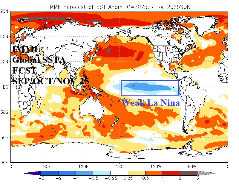
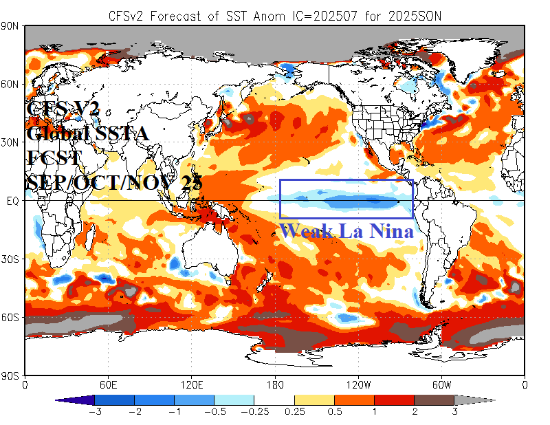
Fig. 6-7: The IMME and NCEP CFS V2 are forecasting weak La Nina to emerge during SEP/OCT/NOV 2025. Each model is consistent with this ENSO outlook.