Below Normal Tropical Cyclone Activity for Both North Pacific and North Atlantic
09/13/2024, 11:55 am EDTU.S. Winter Outlook Emphasizes Cold Risk West; Warm East as Strong -PDO/+AMO Fuel Pattern
11/15/2024, 11:34 am ESTDiscussion: During September 2024 the sea and ice concentration within the polar ice cap is 4th lowest in the 1978-2024 climatology (Fig. 1). By comparison, the polar ice cap is considerably smaller than typical of 40+ years ago (Fig. 2). The modern-day constricted polar ice cap has contributed to a recent trend of above normal snow cover developing early in the northern hemisphere cold season (Fig. 3-4). As the polar atmosphere cools due to seasonality, a tendency for cold wind to stretch across large regions of open ocean close to the northern coasts of Eurasia and North America create advection snows causing abundant early season snow cover in the northern latitudes. During the decades of late last century, early season snow cover advance nearly guaranteed a cold start to meteorological winter across North America and/or Europe. However, nowadays due to the warming mid-latitude oceans identified (mostly) by the increased presence of marine heat waves (MHW), there is a tendency for milder zonal flow in the atmosphere across middle latitudes that prevent southern expansion of snow cover (except Russia where marine influences are limited) and bias the North America and Europe early meteorological winter climate warmer than normal. Note the mild December during the 2014-23 and 2019-23 optimum climate normal (OCN) across the U.S. and Europe although the colder bias across Eastern Russia is trending stronger (Fig. 5-6).
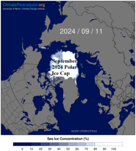
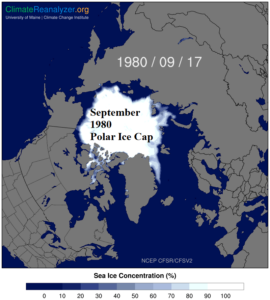
Fig. 1-2: Comparing the SEP-2024 and SEP-1980 sea and ice concentration.
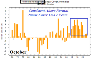
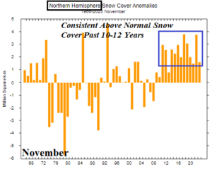
Fig. 3-4: Northern hemisphere snow cover has been typically above too much above normal during October and November during the past decade.
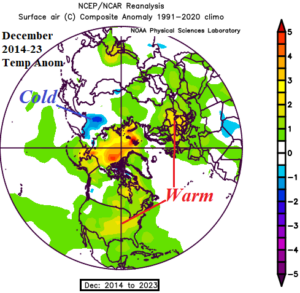
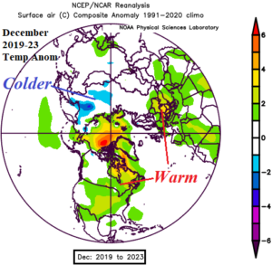
Fig. 5-6: During the past 10 and 5 years the temperature anomaly tendency in December is warmer than normal across the U.S. and Europe.