Marine Heat Waves Boast Major Influence on Northern Hemisphere JUL/AUG Upper Air Pattern
09/06/2023, 7:46 pm EDTCorrelating Northeast Pacific SSTA and Europe Winter Temperature
09/17/2023, 11:02 am EDTHighlight: Understanding Different ENSO Indices
Dr. Olivia Kellner, CIC Lead Climate Research Scientist
Discussion: The Multivariate ENSO Index (MEI.v2) and the Niño 3.4 Index value are two (of many) indices used to monitor the behavior and evolution of the El Niño Southern Oscillation (ENSO). However, these two indices cannot be used as an apples-to-apples comparison. Both are distinctly different from each other in spatial resolution, temporal resolution and ocean-atmospheric variables considered in the computation of the indices.
The MEI.v2 index is developed utilizing an Empirical Orthogonal Function (EOF). An EOF (also known as Principle Components Analysis in other fields) is a mathematical approach that takes a set of highly correlated variables (in this case ocean and atmospheric variables of temperature, sea level pressure, zonal and meridional surface wind components, and outgoing longwave radiation that are all impacted by a change in state of the Southern Oscillation Index), and derives a variable that is a linear combination of all considered variables that explains the most variance within the dataset considered. Several iterations of this approach are executed until all variance in the dataset is explained. The result is the MEI v.2 index value. The observations that are used to compute the EOF for the MEI.v2 index value are computed for 12 overlapping bi-monthly seasons (e.g., Dec-Jan, Jan-Feb…. Nov-Dec). This allows the index to account for seasonality (i.e., the lag in atmospheric response to changes in SST) and reduce intra-seasonal variability. Data observations to compute the MEI.v2 are collected over a spatial domain spanning 30°S-30°N and 100°E-70°W. Values 0.5 or higher are classified as an El Niño phase and values of -0.5 or lower are classified as a La Niña phase.
The Niño 3.4 Index value is calculated via sea surface temperature (SST) data collected across a spatial domain of 5N-5S, 170W-120W. Contrast to the bi-monthly observations for MEI, Niño 3.4 index calculates a 5-month running mean value of SSTs over the defined spatial domain, and El Niño or La Niña events are defined when the Niño 3.4 SSTs exceed +/- 0.4C for a period of 6+ months. Note that Niño 3.4 ONLY considers SSTs, and not other atmospheric variables that are used to characterize the behaviors of an El Niño or a La Niña.
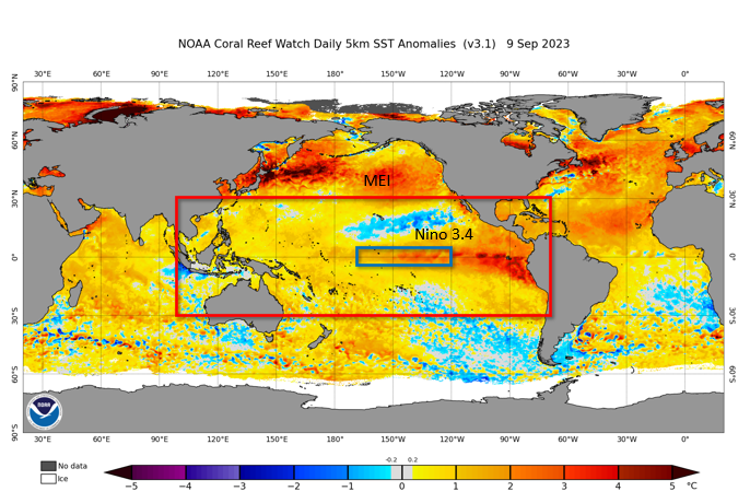
Below is an image showing the difference in spatial extent of both indexes. Overlaying the domain of both onto the most recent SST map, one can see the concentration of high SST anomalies in the Niño 3.4 index region, versus the less concentrated and even cooler SST anomalies that are factoring into the MEI v.2 index calculation (among the other variables previously mentioned).
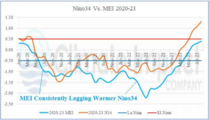
In reviewing the most current observations of these two datasets, one can see that Niño 3.4 indicates we have entered an El Niño, whereas the MEI indicates we have not yet entered an El Niño. Because the MEI index utilizes atmospheric variables, variables which are influenced by SST anomalies, to define if an El Niño or La Niña is present over a significantly larger spatial domain, the natural lag in atmospheric response to SST anomalies within the region manifests in the monthly MEI values (i.e., an El Niño will arrive later than with Niño 3.4. Niño 3.4 only utilizes SST data from a much smaller domain to define which state of ENSO is present in the global climate system.

Fig. 1: Area of quantification of the multivariate ENSO index compared to Nino34 SSTA.

Fig. 2: The multivariate ENSO index indicates neutral ENSO phase as of JUL/AUG 2023 while Nino34 SSTA has surged into moderate-to-strong El Nino phase.

