Understanding The Difference Between Multivariate ENSO Index and Nino34 SSTA Index
09/13/2023, 8:17 am EDTIncreased Solar Activity/Decrease in Sudden Stratospheric Warming Events
10/04/2023, 11:05 am EDTHighlight: October Northeast Pacific SSTA & Following Winter Europe Temperature; Warm Northeast Pacific implies Mild Europe Winter
| Northeast Pacific | Europe Winter Climate | |
| 1994-95 | Warm | Warm |
| 1995-96 | Cold | Cold |
| 1996-97 | Cold | Cold |
| 1997-98 | Warm | Warm |
| 1998-99 | Cold | Cold |
| 1999-00 | ||
| 2000-01 | Warm | Warm |
| 2001-02 | ||
| 2002-03 | ||
| 2003-04 | ||
| 2004-05 | Warm | Warm |
| 2005-06 | ||
| 2006-07 | Warm | Warm |
| 2007-08 | ||
| 2008-09 | Cold | Cold |
| 2009-10 | Cold | Cold |
| 2010-11 | Cold | Cold |
| 2011-12 | ||
| 2012-13 | Cold | Cold |
| 2013-14 | ||
| 2014-15 | Warm | Warm |
| 2015-16 | Warm | Warm |
| 2016-17 | Warm | Warm |
| 2017-18 | Warm | Warm |
| 2018-19 | Warm | Warm |
| 2019-20 | Warm | Warm |
| 2020-21 | Warm | Warm |
| 2021-22 | ||
| 2022-23 | Warm | Warm |
Table 1: During the past 30 years, there is a tendency for correlation between Northeast Pacific SSTA patterns in October and the following wintertime upper air pattern that produce the Europe thermal regime.
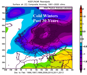
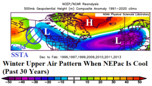
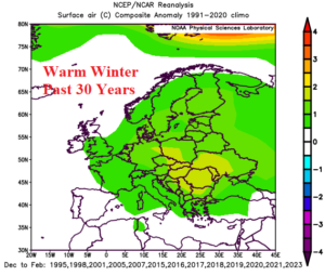
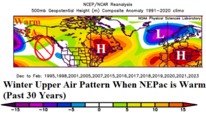
Fig. 1-4: Temperature anomalies for cold (warm) winter seasons during the past 30 years in Europe and the attendant North America/Europe upper air pattern.
Discussion: When was the last cold winter season in Europe? Sprawling meteorological winter (DEC/JAN/FEB) cold was last observed during winter 2012-13. Since that time, 8 of 10 winter seasons have been warmer than normal across Europe (Table 1). During the past 30 years, 7 widespread cold winter seasons have been observed clustering in the mid-to-late 1990’s and in the 2008-2013 period.
The cold winter seasons have produced widespread anomalous chill centered on the Baltic States and extending southward to France, Northern Italy, and Ukraine (Fig. 1). The attendant upper air pattern (Fig. 2) has featured a bold cold trough over Europe associated with a Greenland high-pressure blocking pattern known as negative North Atlantic oscillation (-NAO). Farther upstream, the -NAO pattern stretches an upper trough from Western Canada to the East U.S. In the Gulf of Alaska, the SSTA pattern is colder than normal in each of these cold winter years for Europe.
During warm winter seasons, most of which (from the past 30 years) have occurred within the past 10 years, the anomalous warmth is profound and centered on Poland to Romania and Ukraine (Fig. 3). Warm winter in Europe is well-correlated with warm SSTA patterns in the Northeast Pacific in which the prevailing upper air pattern flips to high-pressure ridging from Alaska to the Northeast U.S. to Southeast Europe (Fig. 4). A cold trough emerges over Scandinavia and the high- pressure block over Greenland is gone.
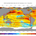
The tendency for warm Northeast Pacific SSTA during the past 10 years began with emergence of the Northeast Pacific “warm blob” in late 2013. The “warm blob” became known as a persistent marine heatwave (MHW) prevailing in this region for much of the past decade. The current MHW, given a number by NOAA (NEP23A), suggests the Northeast Pacific is likely warm again for upcoming winter implying above normal anomalous warm climate risk for winter 2023-24 in Europe.
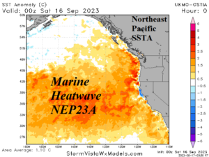
Fig. 5: The Northeast Pacific SSTA pattern identifies the presence of another ongoing marine heatwave (NEP23A).