Western Europe Rains in the Forecast (Mostly) Miss Northwest Africa Drought
02/09/2024, 8:36 am ESTSolar Cycle 25 Intensification Rate Eases
02/13/2024, 8:32 am EST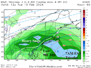
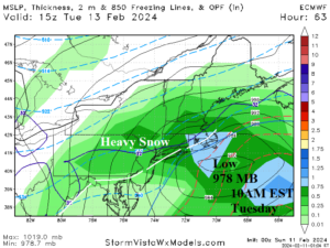
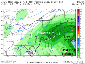
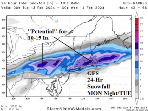
Fig. 1-4: Mega-cluster ensemble projections of northern hemisphere temperature anomaly patterns through the next 15 days and the ECM 6-10-day stratospheric warming event.
Northeast U.S. storm discussion: Mentioned earlier is the continued vigorous central tropical Pacific MJO igniting “atmospheric river” storms into California. The MJO is also inspiring storms from Old Mexico across the Gulf and through the East U.S. Most of these during winter 2023-24 have favored rainfall, especially near the coast. However, Tuesday’s storm is different. This time, phasing of the subtropical and polar jet streams take place over the Northeast U.S. to spawn an impressive 975 MB “bomb cyclone” east of Nantucket and a change from a large veil of rain to all snow as the storm progresses through Pennsylvania and New Jersey to New England on Tuesday. The storm is east of Southern New Jersey by dawn Tuesday causing a large area of heavy snow well away from the Northeast Corridor Coast (Fig. 1). As the storm moves south of Nantucket by 10AM Tuesday (Fig. 2), the generating chilly air mass is sufficiently cold to cause heavy snow for coastal communities (except Cape Cod). Storm intensity is exceptional therefore snowfall rates are easily in the 1-2 inch/hour rate for southern New England to southeast New York. By 1PM EST, surface pressure plummets to 975 MB and a cold wind infiltrates Cape Cod (Fig. 3). All southern and eastern portions of New England are observing heavy snow and high wind. Using GFS, snowfall amount potential is in the 10-15 in. range from the northern half of Pennsylvania to southern New England (Fig. 4). The storm winds down Tuesday evening.