Northeast U.S. Snowstorm
02/11/2024, 10:06 am ESTSo Where Is The Cold Air?
02/15/2024, 7:30 pm EST
Fig. 1: Latest NOAA/NWS weather watch, warning, and advisories.
Discussion: Theme of the morning report is “less intense”. Beginning with the Northeast U.S. snowstorm, Winter Storm Warnings shift south and constrict overnight (Fig. 1) as the faster moving storm has limited time to deposit as much snow as previously indicated. The NBM model indicates a large swath of 4-6 in. of new snow for the northern Mid-Atlantic/southern New England States today (Fig. 2). The storm focus shifts back to the West Coast for the remainder of this week with rain, snow, and wind affecting many areas (Fig. 3). Regarding the arctic air, stratospheric warming causes a large arctic air mass to develop this week across Eurasia. A piece of that air mass will work into Canada with limited influence on the U.S. The cold air surge is to China next week (Fig. 4). Solar Cycle 25 was off to a roaring start regarding sunspot activity in 2024 but has eased back toward the NASA Solar Cycle 25 peak forecast for late this year and 2025 during the past couple months (Fig. 5). The U.S. gas population weight HDD forecast continues to trend milder (Fig. 6).
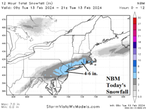
Fig. 2: The NBM snowfall forecast for the Northeast U.S. today.
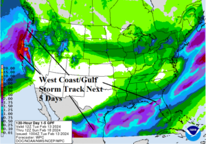
Fig. 3: The NOAA/WPC 5-day quantitative precipitation forecast for the U.S.
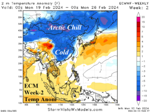
Fig. 4: ECM “weeklies” project cold weather into China next week.

Fig. 5: Solar cycle 25 has eased intensity during the past couple months.
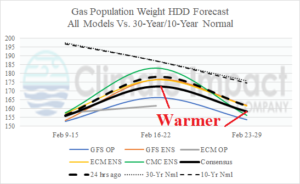
Fig. 6: The U.S. gas population weight HDD forecast utilizing all models, their consensus, and comparing with 24 hours ago and the 10-year/30-year normal.