Is New Wet Bias Over Western Australia Inspired by Warming Southeast Indian Ocean Tropical Waters?
02/27/2024, 7:29 pm ESTMidday 12Z GFS Was Dry in the 15-Day Forecast for the Smokehouse Creek Fire Zone
03/01/2024, 1:21 pm EST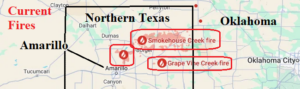
Fig. 1: Location of the Smokehouse Creek fire in northern Texas.
The Smokehouse Creek fire continues to expand and intensify primarily located in northern Texas but now reaching into Oklahoma. High wind is generated by the fire enhanced by synoptic scale wind this afternoon and tomorrow afternoon averaging 20-25 mph with gusts to 40 mph from the south today (Fig. 2) and west tomorrow (Fig. 3).

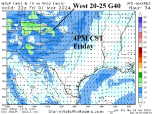
Fig. 2-3: The 12Z GFS projects high wind episodes this afternoon and tomorrow afternoon near the Smokehouse Creek fires.
As a reminder, ahead of the tropical cyclone season beginning in 3 months, the Main Development Region for hurricanes is the warmest compared to normal on record for this time of year (Fig. 4). The very warm ocean surface is likely to last into the tropical cyclone season fueling above normal hurricane numbers and intensity.
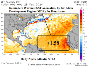
Fig. 4: The daily North Atlantic SSTA analysis reveals record warmth in the Main Development Region for North Atlantic hurricanes.
The 12Z GFS pushes warmth into the East with slightly less ferocity in the 6-10-day period while West U.S. chill expands eastward (Fig. 5). In the 11-15-day period, the warmth retreats to Canada although extending to the North-central and Northeast U.S. (Fig. 6). As stated earlier this week, -AO/-NAO forecasts remain intact therefore a cooler trend in the eastern half of the U.S. expected to evolve faster than models suggest. The MJO forecast is not supportive of a super stormy U.S. pattern for next week and the 12Z GFS is not as wet as indicated 24 hours ago (Fig. 7).

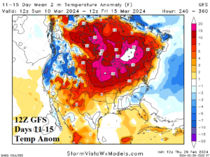
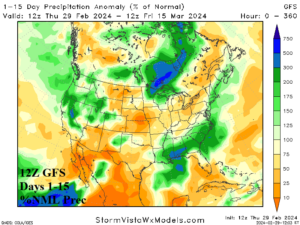
Fig. 5-7: The 12Z GFS medium-range temperature anomaly forecast and 15-day percent of normal precipitation outlook.
| EIA End | Forecast | 12-Hour Change | 24-Hour Change | 30-Year Normal | 10-Year Normal |
| 2/29 | 135.9 | -0.1 | 0.0 | 175.8 | 174.6 |
| 3/7 | 119.1 | -1.6 | +3.0 | 163.6 | 160.3 |
| 3/14 | 118.7 | -10.7 | +20.8 | 150.8 | 145.6 |
Table 1: The 12Z GFS U.S. gas population weight HDD forecast compared to 12 and 24 hours ago.