Smokehouse Creek Fires Receive Synoptic Scale High Wind
02/29/2024, 12:53 pm ESTLatest EDDI Analysis Reveals Midwest U.S. Drought Concern
03/03/2024, 12:57 pm EST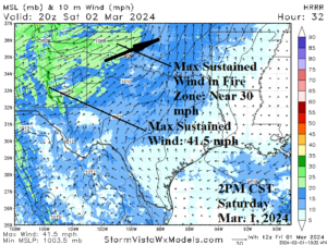


Fig. 1-3: Wind events over the next few days affecting the Smokehouse Creek fire zone (top) and 15-day dry forecast.
Discussion: A surge of strong west to southwest wind extends to the Smokehouse Creek fire zone peaking tomorrow afternoon with sustained west to southwest wind near 30 mph on the western edge of the fire zone (Fig. 1). In this scenario, expansion of the fires eastward into Oklahoma is expected. On Sunday, wind speeds ease slightly while the wind direction is southwest. Tuesday night, wind shifts to north-northeast at 10-20 mph (Fig. 2). The 12Z GFS indicates little or no rain during the latest 15-day outlook across Northern Texas (Fig. 3).
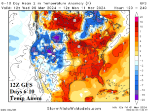
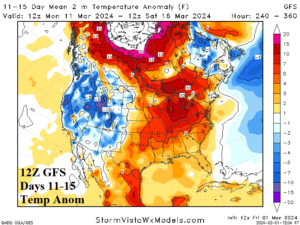
Fig. 4-5: The 12Z GFS medium-range temperature anomaly forecast and 15-day percent of normal precipitation outlook.
The 12Z GFS medium-range forecast remains warm in the East but substantially less warm compared to 24 hours ago and the cooler trend should continue over the weekend (Fig. 4-5). The U.S. gas population weight HDD forecast is trending closer to normal for mid-month (Table 1).
| EIA End | Forecast | 12-Hour Change | 24-Hour Change | 30-Year Normal | 10-Year Normal |
| 2/29 | 110.7 | -2.0 | -8.5 | 163.6 | 160.3 |
| 3/7 | 131.5 | +2.2 | +12.8 | 150.8 | 145.6 |
| 3/14 | 129.0 | +1.5 | +3.6 | 137.2 | 131.4 |
Table 1: The 12Z GFS U.S. gas population weight HDD forecast compared to 12 and 24 hours ago.
NOAA/CPC indicates heavy precipitation risk for the West Coast and southeast quadrant of the U.S. (Fig. 5).
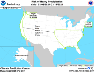
Fig. 5: NOAA/CPC heavy precipitation risk areas for late next week/weekend.