North Atlantic Basin Tropical Cyclone Season Scorecard
08/11/2023, 8:07 am EDTReal-time Extreme Weather Forecasts Driven In-part By Warmer Than Normal Ocean
08/17/2023, 8:18 am EDTHighlight: Tropics starting to activate.

Fig. 1: Satellite view of the North Atlantic basin and primary features.
Today’s discussion: Two new tropical waves are apparent in the morning analysis (Fig. 1). The first, located near 30W, is weak but expected to drift westward with some development possible over the next 5 days. A shear axis is ahead of this tropical wave in the central North Atlantic tropics. NOAA/NHC indicates only a 10% chance of a tropical cyclone in the 3-5-day forecast. The second tropical wave, still over West Africa, is stronger. This system moves into the North Atlantic later today and drifts west to west-northwest over the next 5 days with a 30% chance of becoming a tropical cyclone in the 3-5-day period. A large mass of thunderstorms in the western Caribbean Sea are monitored for possible development. The most likely scenario is development of an East Pacific tropical cyclone to the south of Southeast Mexico will cause energy in this area to shift westward. Consequently, the western Caribbean Sea convection is not likely to organize and gain strength. The GFS continues to indicate a problem developing in the Gulf of Mexico in the 11-15-day period (Fig. 2).
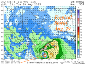
Fig. 2: GFS has forecast some sort of a tropical cyclone in the Gulf of Mexico during the 11-15-day period for several days. The latest potential scenario is a tropical storm near Brownsville, TX on August 29.