North Atlantic Tropics Beginning to Become Active
08/15/2023, 8:12 am EDTOnset of +IOD Pattern Helps Maintain Dry India Climate
08/18/2023, 12:14 pm EDTDiscussion: A warmer than normal ocean surface causes two types of weather patterns. The warm oceans over time warm the atmosphere above and cause above normal risk of stronger subtropical ridging. When these high-pressure ridge areas extend over land, hot and dry weather develops promoting drought. Conversely, when tropical or conventional storms move near or across these large areas of warmer than normal ocean water, the increased moisture in the lower atmosphere caused by the ocean warming is entrained into the storm increasing intensity. Storms encountering a land mass will unload excessive rainfall in this scenario. There are many examples of these circumstances in recent years especially with the increased frequency and strength of large marine heat waves. Today’s NOAA/WPC quantitative precipitation forecast (QPF) is a real-time forecast of the conditions described. A tropical cyclone moving over much warmer than normal water south and east of Mexico will become a major hurricane (Hilary). This system moves northward and into Southern California unloading a historic flooding episode this weekend/early next week. Meanwhile, a stalled frontal system gains tropical characteristics to unload heavy rains on Florida through the next several days. The influence of the much warmer than normal North Atlantic basin increases strength of the subtropical high to cause extreme heat and no rain over the Great Plains and Mid-south U.S. through the next week.
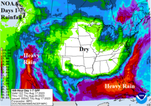
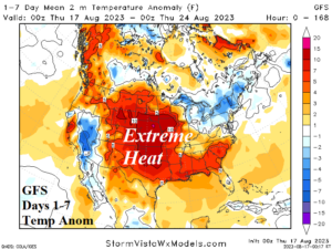
Fig. 1-2: NOAA/WPC 7-day quantitative precipitation amount forecast and the GFS 7-day U.S. temperature anomaly forecast.