Focus on Today’s Northeast U.S. Squall Line
12/11/2024, 8:50 am ESTCold Snap Next Few Days East U.S., Another One Second Week of January
12/20/2024, 10:58 am ESTHighlight: Regional SSTA patterns bring surprising climate regimes.
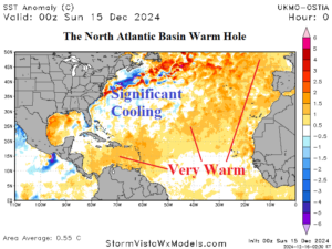
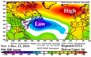
Discussion: Typical of climate pattern(s) nowadays, regional SSTA are influencing local climate in unexpected ways. The best recent example is the cooling of the western North Atlantic basin (Fig. 1) initiated by north-turning tropical cyclones during the late warm season. The cooler waters of the western North Atlantic basin combined with the long-term anomalous warmth of the east and north basin has generated a calendar autumn semi-permanent low-pressure area off the U.S. East Coast and compensating upper ridge over Western Europe (Fig. 2). The low-pressure area off the U.S. East Coast has invited surprising chill to the East U.S. as meteorological winter begins. A careful eye on this western North Atlantic “cool pool” which could sustain cold period support in the East U.S. through mid-winter if the waters fail to warm.
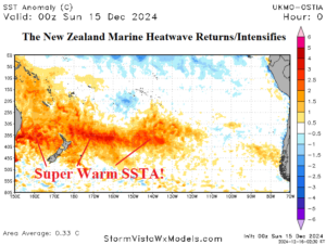
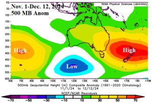
Another vivid example of regional SSTA influence on climate is the return and rapid intensification of the New Zealand marine heatwave (Fig. 3). Since early November, the MHW is well-correlated to strong subtropical ridging over East Australia (Fig. 4) causing a vigorously hot late calendar spring.


Fig. 1-2: The western North Atlantic “cool pool” and the attendant cold trough aloft responsible for inviting surprisingly cold periods to the East U.S. in December.


Fig. 3-4: The daily South Pacific SSTA analysis identifying the New Zealand marine heatwave and the attendant strong subtropical ridge.
