October 2025 North America & Eurasia Snow Cover Report
11/05/2025, 3:54 am EST
Climate Impact Company U.S. Month 1-4 Ahead Outlook
Issued: Friday, November 7, 2025
Highlight: Winter 2025-26 is adjusted colder, especially East in January.
Executive summary: The Climate Impact Company month 1-4 outlook valid DEC-25 through MAR-26 is updated. The forecast is trending colder. The North-central U.S. cold anomalies expand, and the Northeast/Mid-Atlantic are adjusted cooler to near normal. Cold outbreaks cover the suddenly snowbound Northern U.S. in December, a January cold surge into the East U.S., and Western Canada to North-central U.S. cold (possibly reaching Texas) in February. Stratospheric warming events are above normal risk. However, the primary driver of the colder forecast is increased snow cover. Midwest U.S. drought eases, Southern U.S. drought expands, and Southwest U.S. drought advances into California. The least confident part of the forecast is West Coast dryness. An active Madden Julian oscillation is expected during the winter season which, if sufficiently intense, could cause stratospheric warming. The active MJO also weakens La Nina by late winter.
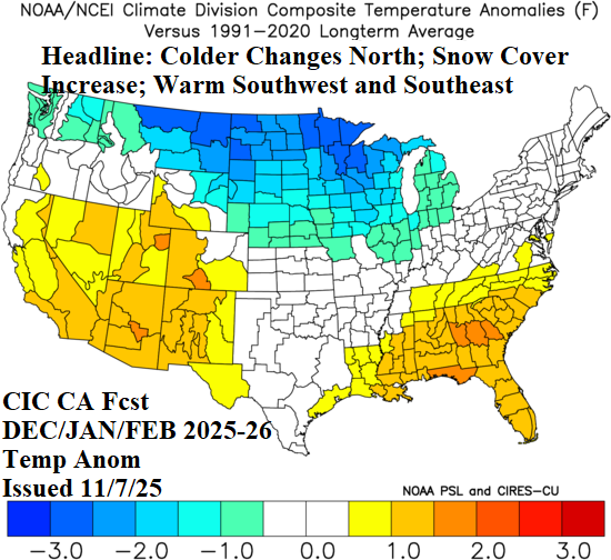
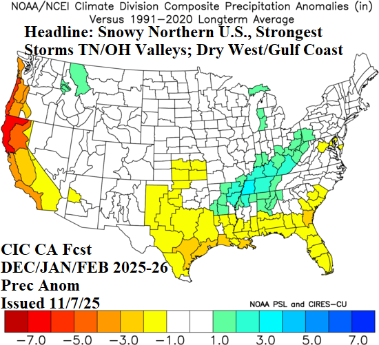
Fig. 1-2: The Climate Impact Company DEC/JAN/FEB 2025-26 constructed analog temperature/precipitation anomaly outlook.
Climate discussion: The outlook is based on 4 climate factors: 1.) El Nino southern oscillation; 2.) Persistence; 3.) Risk of stratospheric warming; and 4.) Optimum climate normal (OCN).
Currently, ENSO phase is weak La Nina (Fig. 3). However, the tropical SSTA pattern (also) features a robust negative Indian Ocean dipole (-IOD) and the combination of -IOD and weak La Nina causes anomalous warm sea surface temperature anomalies (SSTA) to gather across the Maritime Continent area to the north of Australia westward to the Indian Ocean. The anomalous warm water in this zone suggests that Madden Julian oscillation (MJO) events born in the Indian Ocean tropics can intensify shifting eastward absorbing the upper ocean heat of the far West Pacific.
Strong MJO episodes occurring during winter are one way to trigger sudden stratospheric warming (SSW) events as their attendant heat is driven poleward and upward into the upper atmosphere as Rossby Waves (RW). Consequently, the risk of SSW occurring during winter 2025-26 is above normal. Careful monitoring of the MJO, especially stronger than normal events, is required this winter season. A 2-3-week lead time of SSW is available if a strong MJO is developing.
Presence of a stronger than normal MJO regime also erodes La Nina. Most dynamic models forecast La Nina to end early in 2026 with continued MJO activity pushing anomalous warm water eastward across the tropical Pacific triggering El Nino by APR/MAY 2026 (Fig. 4).
The climate of the current decade, especially autumn of 2021 and last year has strong similarities (Canadian high pressure) with 2025 and was added to the constructed analog forecast. Additionally, the accelerating warming of the mid-latitude ocean, which has an influence on climate sometimes as strong as ENSO, is added to the constructed analog as OCN (10-year normal).
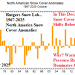
Finally, snow cover presence is required to cause and sustain anomalous cold air masses. The constructed analog process (defined above) identifies warm high pressure during mid-to-late autumn causing below normal snow cover in North America (Fig. 5) reversing during meteorological winter as the polar vortex appears (Fig. 6), at times, to cause and sustain snow cover which may shift above normal especially for the Northern U.S.
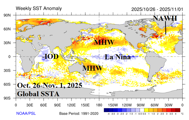
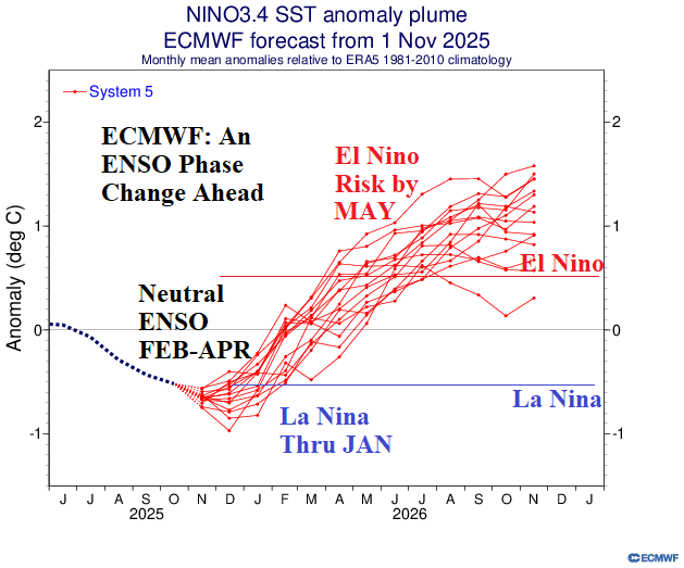
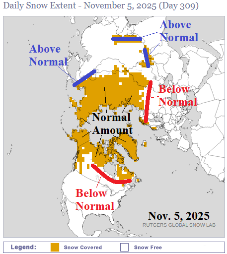
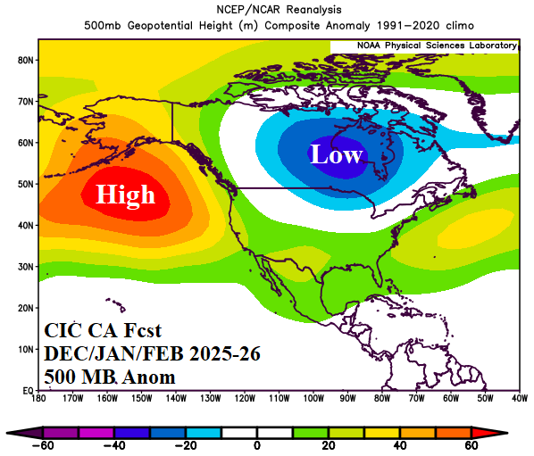
Fig. 3-6: The weekly global SSTA analysis from NCDC/PSD, ECMWF Nino34 SSTA forecast, current northern hemisphere snow cover according to the Rutgers Snow Laboratory, and Climate Impact Company constructed analog 500 MB anomaly forecast for DEC/JAN/FEB 2025-26.
December 2025 outlook: After below normal snow cover of mid-to-late autumn, a sudden appearance and expansion of snow cover across Southern Canada into the Northern U.S. appears. Much of the Northern U.S. observes a White Christmas. The snow cover invites and maintains anomalous cold weather during early winter. South of snow cover, over-achieving warmth is featured across the southern half of the U.S.
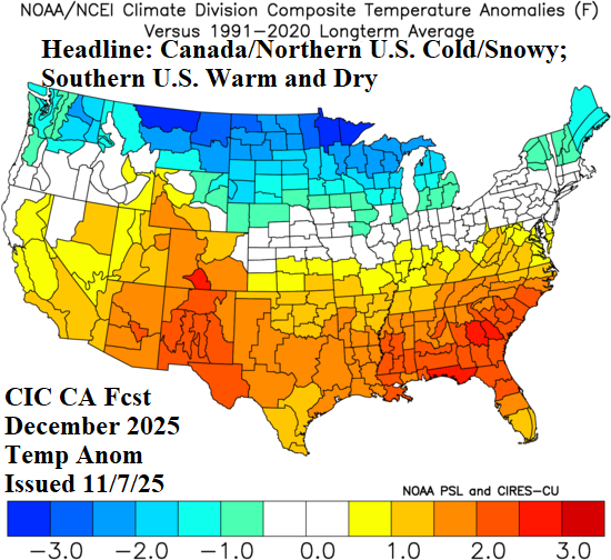
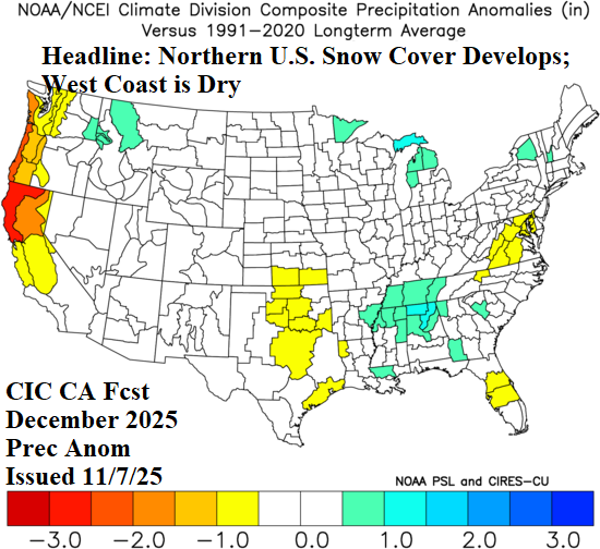
Fig. 7-8: The Climate Impact Company December 2025 constructed analog temperature/precipitation anomaly outlook.
January 2026 outlook: The early winter chill, gathering across the Southern Canada/Northern U.S. snow cover is released into the East U.S. during mid-winter. An SSW event may be involved. Of particular interest is the cold forecast across the Great Lakes region. A considerable amount of snow could produce favoring Western New York to Eastern Ohio. Also subtly indicated is above normal snowfall for Coastal New England. Otherwise, mid-winter is remarkably un-stormy and warm and dry in the West.
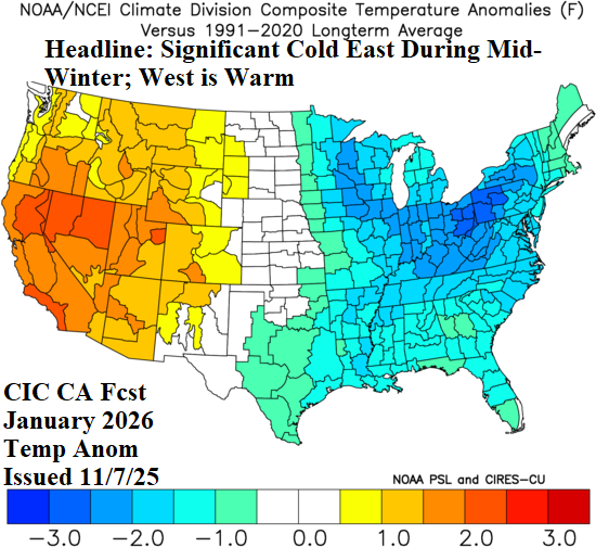
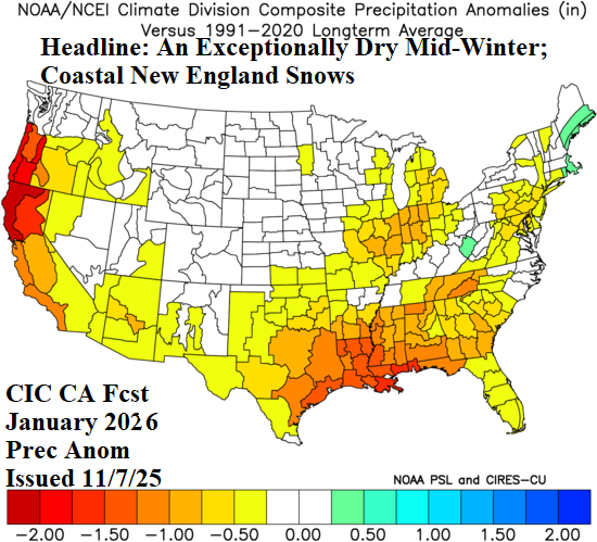
Fig. 9-10: The Climate Impact Company January 2026 constructed analog temperature/precipitation anomaly outlook.
February 2026 outlook: After a relatively storm-free mid-winter, February storms are frequent in the Mid-south U.S. to the Ohio Valley and Appalachian States. Given the cold air supply across the North-central U.S., the storm track is likely to produce significant snow (and ice) on the west and north side which could cause over-achieving cold to extend farther east and south than indicated. The cold anomaly across the northwestern Great Plains to Montana features arctic air. The West Coast and Gulf Coast stay dry. The Southeast is quite warm during late meteorological winter.
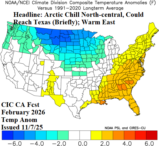
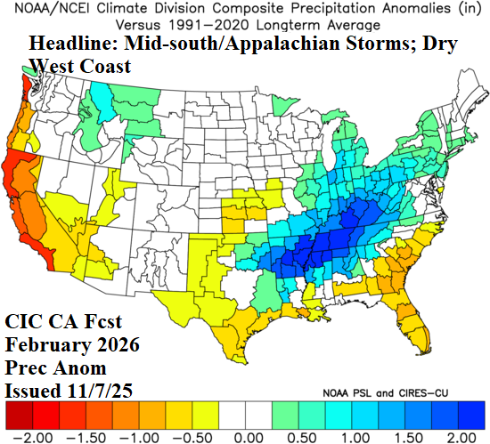
Fig. 11-12: The Climate Impact Company February 2026 constructed analog temperature/precipitation anomaly outlook.
March 2026 outlook: The early meteorological spring 2026 forecast is consistent with a colder/wetter shift in the West, storminess Mid-south States to the Ohio Valley, and warmer than normal climate centered on Texas extending eastward across the Gulf States.

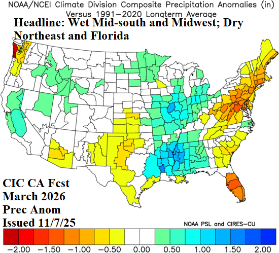
Fig. 13-14: The Climate Impact Company March 2026 constructed analog temperature/precipitation anomaly outlook.