Active Madden Julian Oscillation Combined with Warming Stratosphere Creates Low Risk “Polar Vortex” Threat January 4th
12/26/2023, 8:15 am EST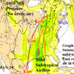
Graph Cast AI-Generated SLP Forecasts Continue To Out-Perform Conventional Models
12/30/2023, 7:51 am ESTChart of the day: North American air masses in 10 days.
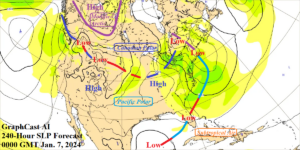
Discussion: Energy markets grapple with risk of arctic air intrusion to the U.S. in 10+ days due to presence of a stratospheric warming event emerging over Eurasia over the next week or so, shifting into northwest North America in 10 days, and likely collapsing in 15 days (according to NOAA/CPC). The forecast trend is a shorter exposure to North America than previously indicated. Consequently, the risk of an arctic outbreak into the U.S. during the first half of January is decreasing. During El Nino winter, the attendant mild bias supports U.S. forecasts (at least the Northern U.S.) trending warmer. To identify arctic air risk in 10 days, the Graph Cast AI forecast is utilized. The model indicates some modified arctic air into Northwest/West Canada while the Northern U.S. is affected by seasonably chilly Canadian polar air, and farther south a seasonably cool (not cold) Pacific air mass is dominant. At the 240-hour mark, GFS indicates a pool of arctic air into Ontario while ECM indicates arctic air from Northwest Canada to Ontario. The Graph Cast AI 240-hour forecast doubts the GFS/ECM arctic air forecast and is preferred based on Climate Impact Company preliminary review of 10-day SLP forecasts in which Graph Cast AI has out-performed GFS and ECM.
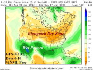
Medium-range 6-10 Day Forecast Valid January 2-6, 2024
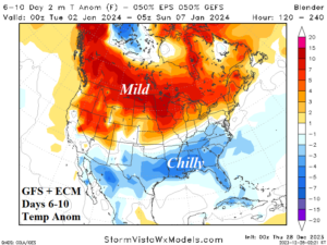
Discussion: Equal weighting from GFS and ECM indicates a chilly regime across the Southern U.S. in the 6-10-day period. The air mass is “polar” in character therefore cool, not cold. Arctic air threat is not evident, therefore Southern Canada/Northern U.S. stays warm.
Medium-range 11-15 Day Forecast Valid January 7-11, 2024
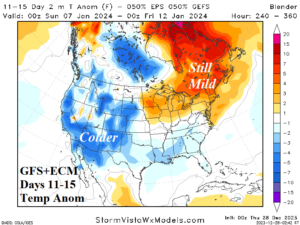
Discussion: Risk of stratospheric warming producing arctic air after 10 days to infiltrate the U.S. is lowering. However, a chilly polar air mass enhanced by increasing snow cover is likely to generate across the West U.S. while cool weather lingers in the southern states.
U.S. Medium-range Precipitation Forecast
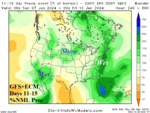
Discussion: The southern storm track is certainly evident in the 6-10-day period and GFS and ECM combine for widespread above normal precipitation in the 11-15-day period. Substantial snow is possible in the 11-15-day period.
Days 16-20 Extended range Temperature Forecast valid January 12-16, 2024 (previous below)
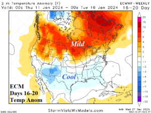
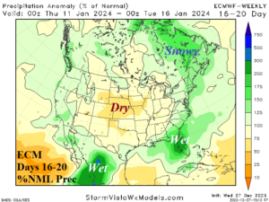
Discussion: ECM indicates no arctic air in Canada in the extended range. Consequently, the Canada/Northern U.S. forecast stays warm. However, the cool El Nino bias for the southern states remains intact.