Doubting U.S. Arctic Air Threat Although West Is Colder In 11-15 Days
12/28/2023, 8:26 am ESTWarm December Departs, Snowy January Ahead in U.S.
01/01/2024, 9:17 am EST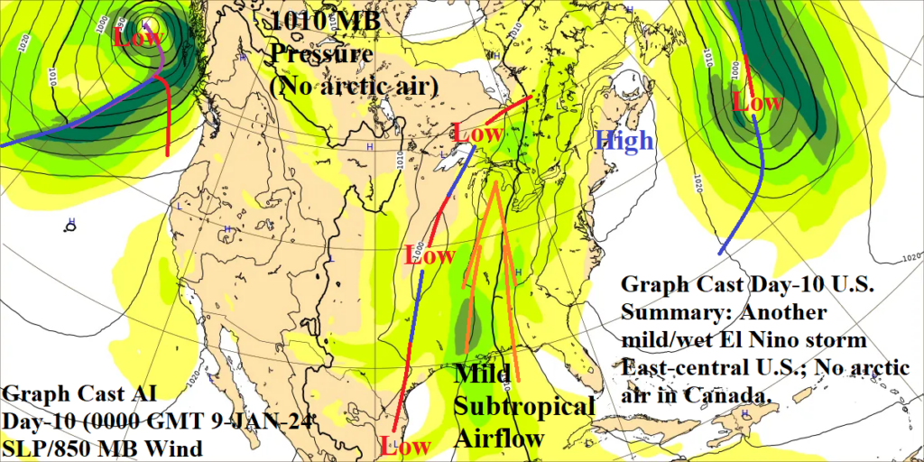
Fig. 1: Graph Cast AI-generated 240-hour SLP/850 MB wind speed forecast for North America with annotated synoptic features.
Discussion: Based on Climate Impact Company review (so far), Graph Cast AI-generated day-10 SLP forecasts are consistently out-performing GFS and ECM. The latest important example was Graph Cast AI doubting risk of arctic air across Southern Canada and possibly into the U.S. (associated with a stratospheric warming event). In fact, today’s day-10 forecast by Graph Cast AI continues to indicate lack of (arctic) high pressure across the southern half of Canada. GFS and especially ECM have arctic air in Central Canada which “looks” perilous given the storm track to the south which could draw the air southward. Also indicated by Graph Cast AI is another mild and wet El Nino storm in the East-central U.S. propelled by a southerly low-level jet (55-65 mph wind at 850 MB) out of the Gulf of Mexico. A preliminary comment regarding North America day-10 forecasts reveals the machine-learning model seems to understand that extreme cold is less likely during El Nino winter enabling continuation of mild/wet El Nino storms at day-10.