Stratospheric Warming Emerges In Early January!
12/22/2023, 1:05 pm ESTDoubting U.S. Arctic Air Threat Although West Is Colder In 11-15 Days
12/28/2023, 8:26 am EST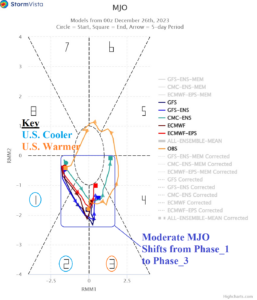
Fig. 1: Madden Julian oscillation 14-day forecast by all models indicating moderate strength of an eastward shift from phase_1 to phase_2 (tropical East Pacific/Atlantic) through 10 days to the Indian Ocean in 11-14 days.
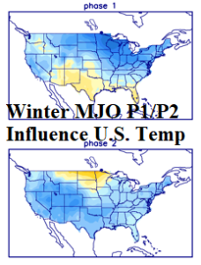
Fig. 2: Typical response of MJO phase_1 and phase_2 of U.S. temperature regimes during January.
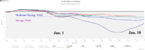
Fig. 3: The North Atlantic oscillation is forecast by all models to shift into moderate to strong negative phase in early January which is a cooling influence on the U.S.
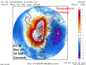
Fig. 4: ECMWF 10-day forecast of 10 MB temperature anomalies reveals a stratospheric warming event stretching from Siberia to northwest North America.
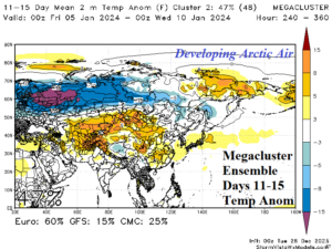
Fig. 5: The stratospheric warming event creates a new cold air source region across Eurasia in 11-15 days.
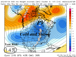
Fig. 6: Mega-cluster ensemble indicates potential for a brief “polar vortex” pattern caused by the combination of the MJO and stratospheric warming event described. However, the risk is low, only 14%.
Discussion: A moderate strength The Madden Julian oscillation (MJO) is shifting from the tropical East Pacific/Atlantic to Africa over the next 10 days (phase_1 and phase_2) to the western tropical Indian Ocean in 11-14 days (Fig. 1). Normally, the MJO transiting through phase_1 and phase_2 brings cooler changes to U.S. climate (Fig. 2). The eastward shifting MJO is influencing the North Atlantic oscillation (NAO) which departs the warm influence on the U.S. of the positive phase during the past 2 weeks to a cooling negative phase forecast for early January (Fig. 3).
Forecast models remain warm due to the El Nino influence. However, a strong stratospheric warming episode across Siberia to northwestern North America remains indicated by forecast models for early January (Fig. 4). As a result, a large cold air mass featuring developing arctic air develops in Eurasia by early January (Fig. 5). The (warm) El Nino influence is trying to prevent (cold) trouble in the U.S. and operational forecast models are struggling to change the warm North America pattern despite colder support from climate signals. However, the mega-cluster ensemble indicates a low risk (14%) of a brief moderate-strength polar vortex pattern centered on January 4th (Fig. 6).
In summary, the combination of an eastward shifting MJO across the tropical Atlantic and stratospheric warming over Siberia to northwest North America increases the risk of a brief sneaky cold pattern in North America. Forecast models indicate a low risk but close monitoring for significant changes of the forecast in early January is warranted. Through 10 days, AI models do not see the cold air risk for the U.S.