Comparing The Mid-January 2024 Cold With Epic “Uri”
01/05/2024, 9:04 am ESTThe January 2024 Polar Vortex Event Ahead!
01/09/2024, 5:21 am ESTHighlight: Colder West/Central (and Texas) ahead. Potent storms across the East! Many weather hazards, some extreme (extreme cold, blizzards, flooding rain) are ahead!
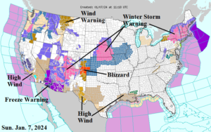
Fig. 1: NOAA/NWS weather watch, warning, and advisory areas.
Discussion: On Sunday morning, a plethora of weather watch, warning, and advisories were issued for much of the U.S. The New England storm roars on with Winter Storm Warning’s issued for New York and much of New England (Fig. 1). A large Southwest U.S. snowstorm propelling heavy snow in mountain areas and a widespread freeze strengthens shifting east today. Blizzard conditions have developed in the southwest Great Plains. The storm will bring heavy snow to the Great Plains to begin the week! High wind is an issue in Texas, California, and parts of the West.
Using Graph Cast AI, today’s New England storm will continue to intensify today as surface pressure drops another 10 MB as the storm moves east of Boston (Fig. 2). The eastward displacement of the storm turns wind into the cold northerly direction causing coastal rains to change to heavy snow today for New England. The storm lingers into tonight. A large swath of New England receives 6-15 in. of snow, the first major snowstorm of the season.
Fig. 2: Graph Cast AI SLP and 850 MB wind speed forecast for 7PM EST this evening.
Today’s Southwest U.S. storm shifts northeastward and becomes another powerful “El Nino” storm as surface pressure plummets to 983 MB Tuesday afternoon in the Ohio Valley (Fig. 3). The Graph Cast AI model indicates a 2-4 in. rainstorm for MON/TUE into the East and Northeast causing flooding for saturated soils from the Mid-Atlantic to New England States (adding snowmelt from current storm). This is an El Nino storm, therefore severe thunderstorms with possible tornadoes affect the north/northeast Gulf of Mexico region and across the Southeast and Florida on Tuesday. The axis of heavy snow (6-15 in.) is from southwest Kansas to just north of Chicago tomorrow night into Tuesday.
Had enough? The late week U.S. storm track increases complexity if that’s possible. Graph Cast AI forecasts another “El Nino” storm as surface pressure plummets to 983 MB (again) next Friday evening in the Ohio Valley (Fig. 4). The storm track is farther west than GFS and ECM. Consequently, this is another heavy rainstorm for the Gulf States and Atlantic Seaboard with another round of significant flooding possible due to a 1-3 in. rainfall. More severe weather including a tornado threat for Florida. This time, AI forecasts harsh cold due to arctic air into the back side of this storm. The result is a potential blizzard from the central Great Plains through Chicago to north of Detroit. High wind and 1-2 feet of snow! Frigid air is surging into this storm causing impossible outside conditions.
Fig. 3: Graph Cast AI SLP and 850 MB wind speed forecast for 1PM EST Tuesday.
Fig. 4: Graph Cast AI SLP and 850 MB wind speed forecast for 7PM EST next Friday.
The large aerial coverage of deep snow cover left behind by the late week storm in the Central U.S. paves the way for a cold surge southward into Texas late next weekend. The arctic air working into the back side of the late week storm surges into Texas next Sunday although some moderation occurs south of snow cover across Texas upon arrival (Fig. 5). The Graph Cast AI forecast projects 1060 MB arctic air in West-central Canada at this time. In this scenario, the zero line reaches Oklahoma on Monday morning, Jan. 15th while teens roar into Dallas and <32F reaches the northwest Gulf Coast. Timing is uncertain, there is a timeframe error of 1-day on the Texas cold. -30’s reach North Dakota early next week.
Fig. 5: Graph Cast AI SLP and 850 MB wind speed forecast for 7PM EST next Sunday.
Subtropical moisture out of the Gulf clashing with central continental arctic air generates another super storm for mid-January. Graph Cast AI indicates a 983 MB low pressure area off the southern New England Coast which is continuing to intensify (Fig. 6). This time, more heavy rain, and flooding on the Northeast Corridor Coast while inland, a major blizzard! Frigid arctic air remains over the Great Plains with moderated arctic air into Texas.
The U.S. gas population weight HDD forecast is very cold for next week (Fig. 7). Interestingly, the ECM is somewhat warmer. The Graph Cast AI forecast is also not as cold as other models for next week due to a warm bias in the East. U.S. heating demand explodes next week averaging about 250 HDD which is shy of the 272 HDD from “Uri” in February 2021. The forecast is looking colder for the Great Plains to Texas while the East avoids the cold but has potent storms.
Fig. 6: Graph Cast AI SLP and 850 MB wind speed forecast for 7PM EST next Monday.
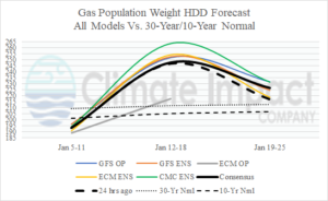
Fig. 7: U.S. gas population weight HDD forecast using all models, their consensus, and comparison with 24 hours ago and the 30-year/10-year normal.