Many U.S. Weather Hazards Ahead (Extreme Cold, Blizzards, and Flooding Rain)
01/07/2024, 9:43 am ESTWet Climate in Panama May Wait Until Q4/2024
01/11/2024, 5:12 pm EST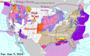
Fig. 1: NOAA/NWS weather watch, warning, and advisory areas.
Discussion: High impact weather, some of it life threatening, is underway and likely to continue through the middle third of January. An intense 983 MB low pressure system is forecast through central Illinois this afternoon. The super low pressure propels high wind able to cause power outages across the Midwest, Southeast, and East U.S. today. High Wind Warnings are issued for much of the Northeast Corridor where substantial power outages are likely tonight. The high wind is accompanied by an ongoing blizzard across the southwest Great Plains which is likely to extend to Iowa and possibly reach Chicago by tonight. Excessive rainfall coupled with saturated soils in the Mid-Atlantic and Northeast (enhanced by snowmelt) is likely due to several inches of rain later today and tonight. A Tornado Watch is in effect for the northeast Gulf States. Meanwhile, the Northwest U.S. is hammered with a massive snowstorm featuring blizzard conditions in the Cascades and damaging wind/heavy rain on the Northwest U.S. Coast. The East U.S. storm is offshore tomorrow followed by more high wind for the Ohio Valley and Northeast Corridor with heavy lake-effect snows extending from Michigan to the Appalachian Spine. By Friday, the Northwest U.S. storm shifts to Arkansas and spawns another high wind/heavy rain event for the eastern third of the U.S. including severe weather in the Gulf States while another blizzard takes shape from the northern Missouri Valley to Chicago to Central Michigan. A 982 MB low pressure system moves across Cleveland, OH Saturday morning causing much of the eastern half of the U.S. to encounter high wind. Another extreme rain event causes more flooding in the Northeast U.S. late this week/early weekend. The feared arctic air is wedging into the North-central U.S. Saturday morning. The air mass surges into Texas by early next week. Medium-range forecasts valid for next week into the following week trend colder for the Central/South/East States!
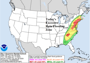
Fig. 2: NOAA/WPC excessive rainfall/flood risk forecast indicates a high impact flooding situation possibly life threatening in the red zones which includes major Northeast U.S. cities from Washington to Boston.
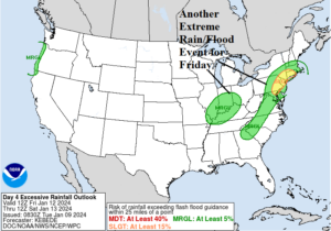
Fig. 3: NOAA/WPC excessive rainfall/flood risk returns to the northern Mid-Atlantic States Friday/Friday night.
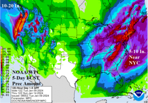
Fig. 4: NOAA/WPC 5-day precipitation amount forecast indicates extreme amount in the Northwest and East U.S.
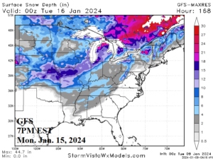
Fig. 5: Snow cover expansion by next Monday evening increases the risk of cold impacts on the South/East U.S. as arctic air pushes southward next week.
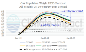
Fig. 6: The U.S. population weight HDD forecast utilizing all models, their consensus, and comparison with 24 hours ago and the 10-year/30-year normal. The forecast trend is sharply colder!