Mid-Troposphere Wet RH Favors Tropical Development
06/16/2023, 9:28 am EDTGFS/ECM Wet Bias in Medium-range Forecasts for Midwest U.S.
06/23/2023, 8:58 am EDTThe NAWH pattern (cool SSTA region off the U.S. East Coast associated with a persistent East Coast upper trough) is a contributor to persistent extreme precipitation patterns across the East U.S. and a micro-climate may be forming. The Midwest States have dried-out rapidly as D2/D3 drought has developed (Fig.1). Meanwhile, wet soil moisture trend in the Southeast U.S. is accelerating due to the recent heavy rainfall. The latest 15-day forecast maintains soaking rains in the Southeast States expanding northward throughout the East while the Midwest stays dry (Fig. 2). The increasingly wet soils in the Southeast signals increased risk of suppressed mid-summer heat while Midwest drought is likely to feedback the atmosphere producing a warm upper ridge causing hotter surface temperatures (worsening drought) during mid-summer.
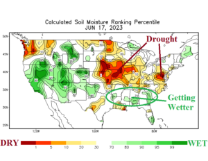
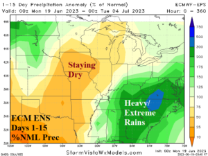
Fig. 1-2: Micro-climate is developing due to persistent dryness in the Midwest and steady wetter soils in the Southeast U.S. Heat should follow the drier soil region while the wetter soil region observes suppressed heat risk.
The latest U.S. medium-range forecast identifies another developing issue. The Texas heat continues, strengthens, and expands. This hot zone is a classic hot air mass source region which can expand to “pulse” into much of the U.S. during mid-summer. During late June, the anomalous heat in Texas remains torrid (Fig. 4). In the 11-15-day period, the heat is expanding across the southern Great Plains and into the Southwest States (Fig. 3). Note that the East avoids any important heat while moderating to near normal.
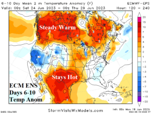
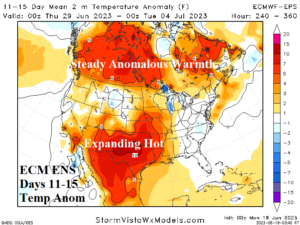
Fig. 8-9: ECM ENS medium-range temperature anomaly forecast.