ERCOT JUN/JUL 2023 CDD Forecast Trending Much Hotter
06/15/2023, 5:47 am EDTMidwest/Southeast U.S. Micro-climate Forming?
06/19/2023, 10:12 am EDTHighlight: Two systems to watch over the weekend.
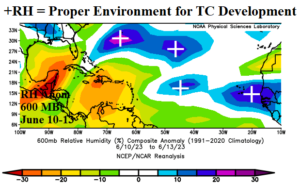
Fig. 1: Mid-troposphere relative humidity anomalies across the tropical and subtropical North Atlantic basin.
Today’s discussion: Although a couple days old, the clear trend of relative humidity anomalies in the mid-troposphere is wetter east of the Bahamas to the central North Atlantic subtropics plus across the central and eastern North Atlantic tropics (Fig. 1). In this zone, any tropical feature is likely to develop given ample mid-tropospheric moisture. Current satellite view of the North Atlantic basin reveals two suspect areas to monitor over the weekend (Fig. 2). A tropical low off the West Coast of Africa continues to organize while drifting due west. NOAA/NHC indicates 50% risk of tropical cyclone development after 48 hours. Note that the projected 10-day track follows the +RH pattern. A second area of convection has blossomed overnight in the southwestern Caribbean Sea. This system may also develop drifting northward and eventually reaching Florida later next week. Both systems have tropical storm intensity potential, but a hurricane is unlikely.
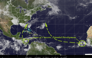
Fig. 2: Satellite view of the North Atlantic basin.