Midwest/Southeast U.S. Micro-climate Forming?
06/19/2023, 10:12 am EDTDamaging Wind Gusts Throughout the Mid-Atlantic Region Today
06/26/2023, 8:04 am EDT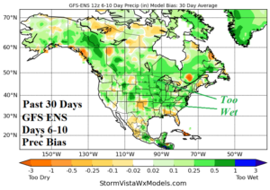
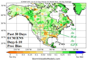
Fig. 1-2: The GFS/ECM (ensemble) 6-10-day rainfall forecast bias past 30 days.
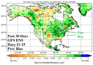

Fig. 3-4: The GFS/ECM (ensemble) 11-15-day rainfall forecast bias past 30 days.
Discussion: Medium-range forecasts across the Midwest U.S. drought area during the past 30 days are too wet especially by the GFS ENS and to a lesser extent by the ECM ENS (Fig. 1-4). The ECM ENS 6-10-day verification is reasonable otherwise a strong wet bias is indicated.
In the U.S. “AG Belt” the overnight 15-day rainfall forecasts vary. Ensembles trend wetter while GFS OP is somewhat drier. Additionally, there is also disagreement on whether the Texas heat can surge northward into the U.S. Corn Belt (or not) as GFS is hot into Missouri in the 6-10-day period but otherwise cooler for the entire Corn Belt and ECM is trending warmer. Given last night’s “panic” ECM “weeklies” the warmer/drier operational ECM solutions are not surprising.
For now, the cooler (and drier) GFS idea is most correct. The North Atlantic warm hole (NAWH) east of the Northeast U.S. Corridor is regaining strength (Fig. 5-6). The influence on climate will be to prevent the Texas high pressure ridge from amplifying into the Midwest U.S. The NAWH needs to weaken for the July hot scenario to emerge in the U.S. Corn Belt as indicated last night by ECM. That trend is likely but less certain than indicated in last night’s “panic” ECM forecast.
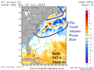
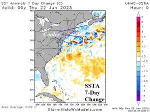
Fig. 5-6: The NAWH pattern and 30-day change.