GFS/ECM Wet Bias in Medium-range Forecasts for Midwest U.S.
06/23/2023, 8:58 am EDTEarly Winter Heat and Dryness in South America
06/28/2023, 5:30 am EDT


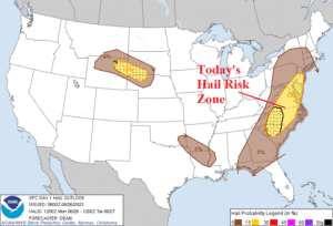
Fig. 1-4: Yesterday’s severe weather reports and today’s severe weather outlook including damaging wind/hail risk areas.
Discussion: At last count, yesterday’s severe weather reports climbed to 557 including 187 hail damage messages of which many included 2-inch (or more) sized hailstones (Fig. 1). A similar outbreak is forecast for the East U.S. today most focused on the Mid-Atlantic region (Fig. 2) where the primary issue is damaging wind gusts (Fig. 3). Damaging hail risk extends from DCA/BWI/PHL to the Carolinas (Fig. 4). Today’s convective available potential energy (CAPE) forecast peaks at 6PM and features 2000-3000 j/kg levels certainly supportive of a major wind and hail episode (Fig. 5). Tornado risk is comparatively low although the entire severe weather risk zone is susceptible to an isolated event. Peak severity of today’s event in the Mid-Atlantic region is 6-7PM when a squall line extends from eastern and northern Virginia through DCA/BWI and northeastward to NYC (Fig. 6). Forecast models indicate the southern storms (Virginia and especially the Carolinas) are big lightning producers while the DCA/BWI/PHL stretch is exposed to both high wind and hail causing potential widespread damage. The heaviest rain (with damaging wind) is across eastern Pennsylvania to NYC and eventually New Jersey. Severe thunderstorms last well into the evening with an ALL CLEAR not likely until very early tomorrow morning.
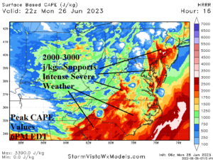
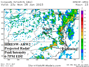
Fig. 5-6: The HRRR model projects today’s peak CAPE values while HIRESW-ARW2 predicts maximum intensity radar depiction for 6-7Pm.