Midwest U.S. Derecho Alert for Today
07/30/2024, 8:08 am EDTBig Rainstorm Ahead for Florida and the East Coast!
08/02/2024, 8:55 am EDT
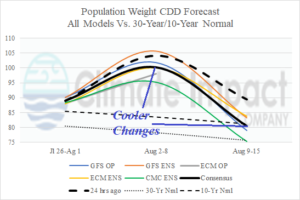
Fig. 1: Today’s U.S. population weight CDD forecast trend is cooler.

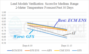
Fig. 2: North America 2-meter temperature forecast verification for the medium-range for the past 30 days.
Discussion: Yesterday’s warm resurgence by GFS in the Aug. 9-15 forecast was spurious. The model correctly shifts cooler overnight and the consensus CDD outlook is markedly less hot next week and cools to normal Aug. 9-15 (Fig. 1). During the past 30 days (July), the 2-meter temperature prediction verification for North America is best forecast by ECM ENS while the volatile GFS is last (Fig. 2). The Artificial Intelligence Forecast System (AIFS) was 4th of 5 leading models.
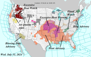
Hot weather expansion continues in the Central, South, and East U.S. Heat Advisories now cover 18 states (Fig. 3) with Excessive Heat Warnings issued for 8 states. Parts of the Mid-Atlantic are added. An Excessive Heat Watch is in effect for the Interior Northwest U.S. Flood Watch areas are issued for gully-washer showers and thunderstorms in Vermont and East Tennessee. A Blowing Dust Advisory will bring difficult outside conditions to Arizona today. Across the northwest quadrant of the U.S., widespread Air Quality Alerts are issued.
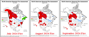
The Camp Fire in Northern California is ranked 5th worst in state history. The fire risk for JUL/AUG/SEP 2024 (Fig. 4) is immense based on the latest NOAA forecast. Affected are many parts of the West U.S., West and Central Canada, the southern Great Plains, and parts of the East U.S.

Fig. 3: NOAA/NWS weather watch, warning, and advisories.

Fig. 4: NOAA fire risk areas (in red) for July, August, and September.
